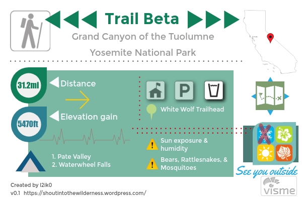
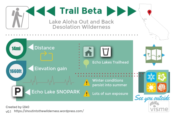
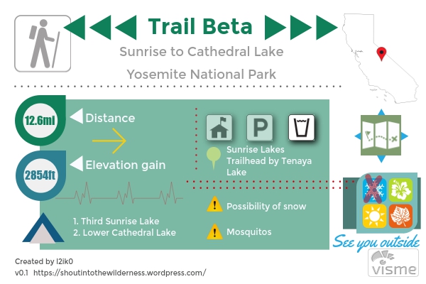
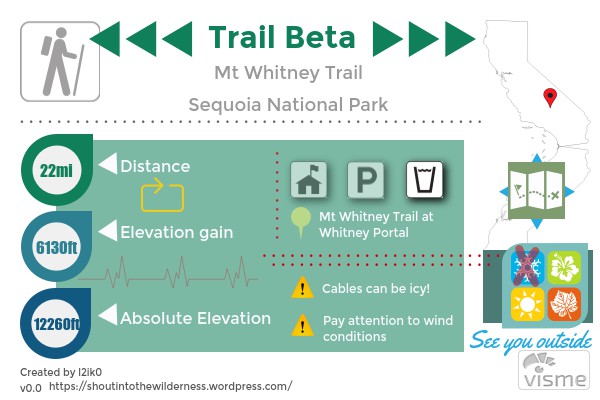
Grand Canyon of the Tuolumne Backpacking

TL;DR

If you’re interest in a 30 mile thru-hike that is just as beautiful as it is exhausting then you should check out Yosemite’s Grand Canyon of the Tuolumne. It drops down into canyon from White Wolf, giving you views of Hetch Hetchy as you follow the Tuolumne River through Pate Valley and back up to Tuolumne Meadows. This is the often recommended direction for this hike. Doing it the opposite way gives a brutal last day of elevation gain. Pate Valley is known for a high incident of bear sightings as well as rattlesnakes and more mosquitoes than you know what to do with.

GCotT

GPS Track and Elevation Data

Thoughts

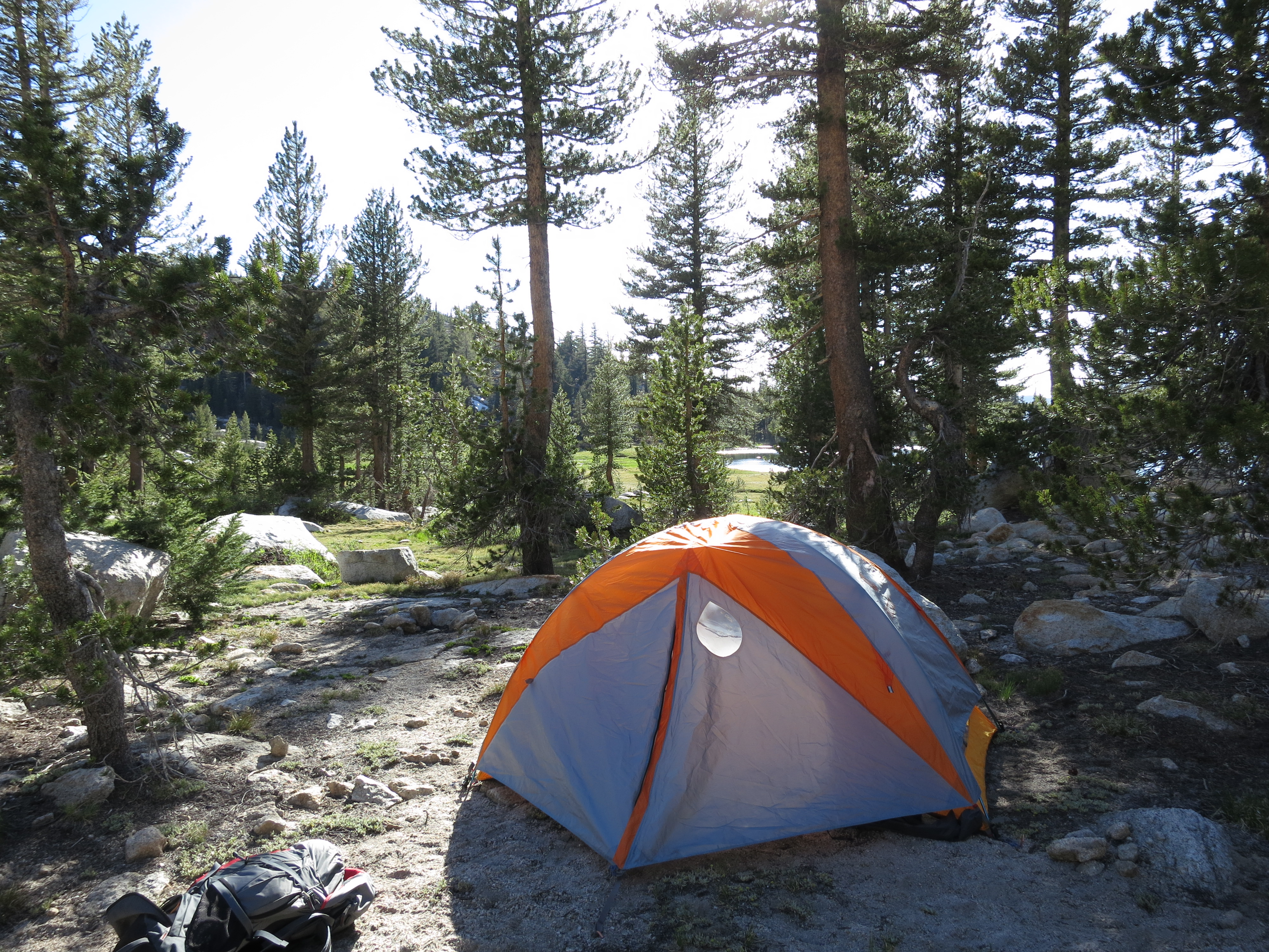
This was our first Yosemite trip of 2017 and I had been pretty stoked about it since getting the permits in February. It was another one of those trips where you do tons of planning and research 6 months before and then don’t do anything until 2 days before leaving. The most difficult aspect of planning this hike is coordinating the transportation. This is a thru-hike so you either need more than 1 car or to hitchhike. The Tuolumne Meadows shuttle doesn’t go to White Wolf. From White Wolf to Tuolumne Meadows, where the hike ends, is a 30-45 minute drive each way. We had a decent size group so our plan of attack was to meet up at White Wolf at 9am, dump all gear and passengers, drive all the cars to Tuolumne Meadows/Glen Aulin Trailhead, then drive one car back to White Wolf. We were able to start hiking by about 11:30am.

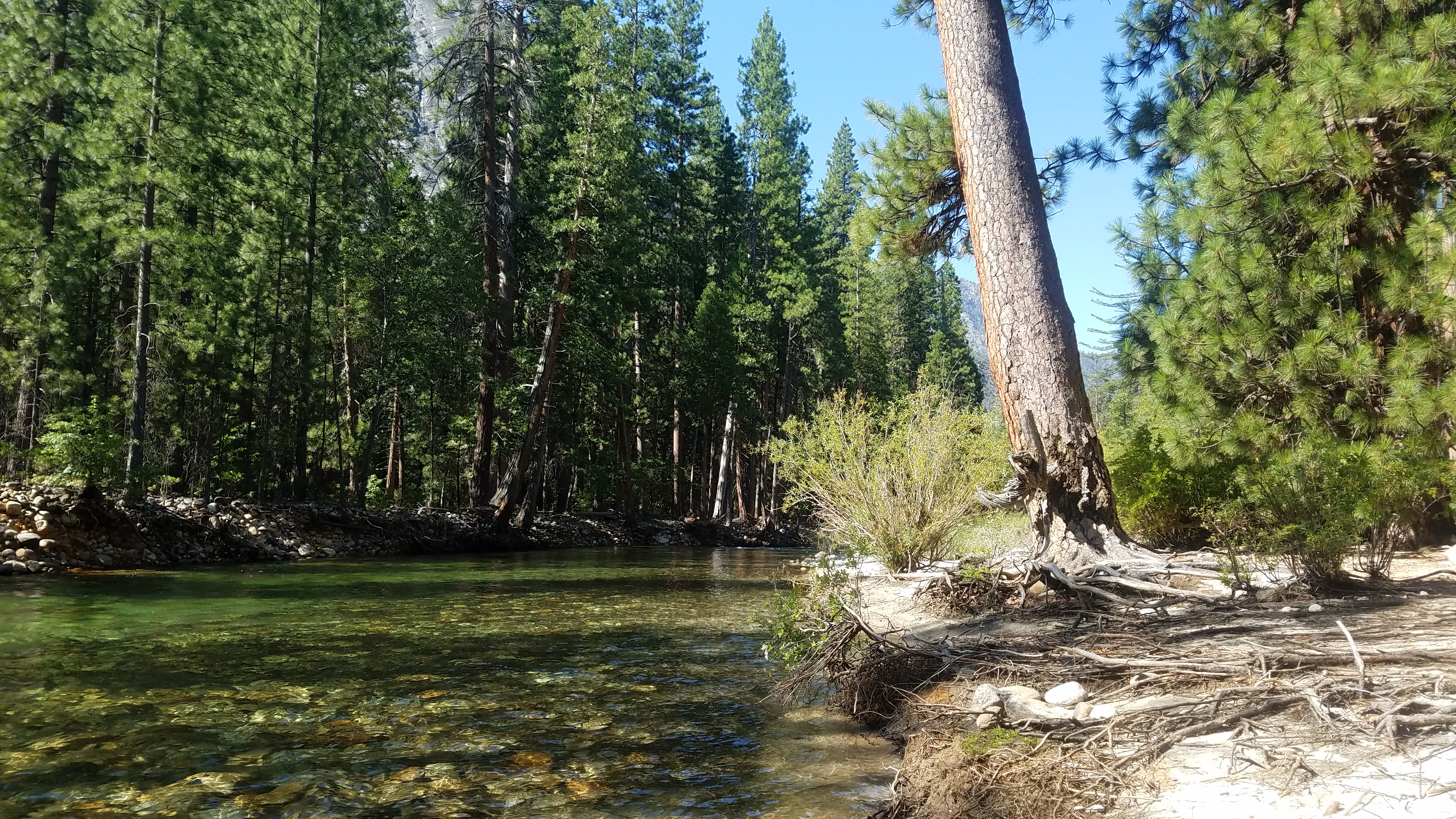
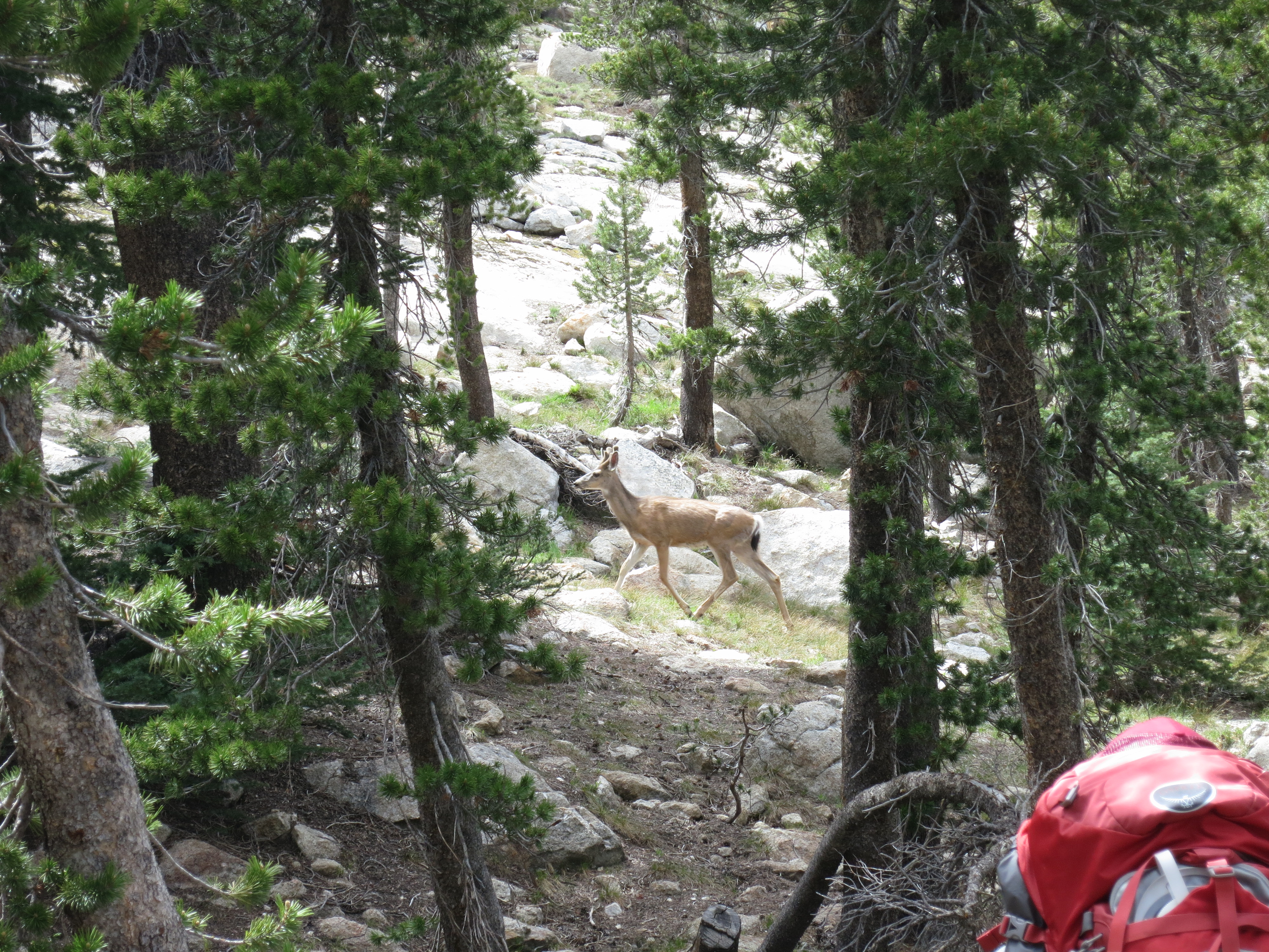
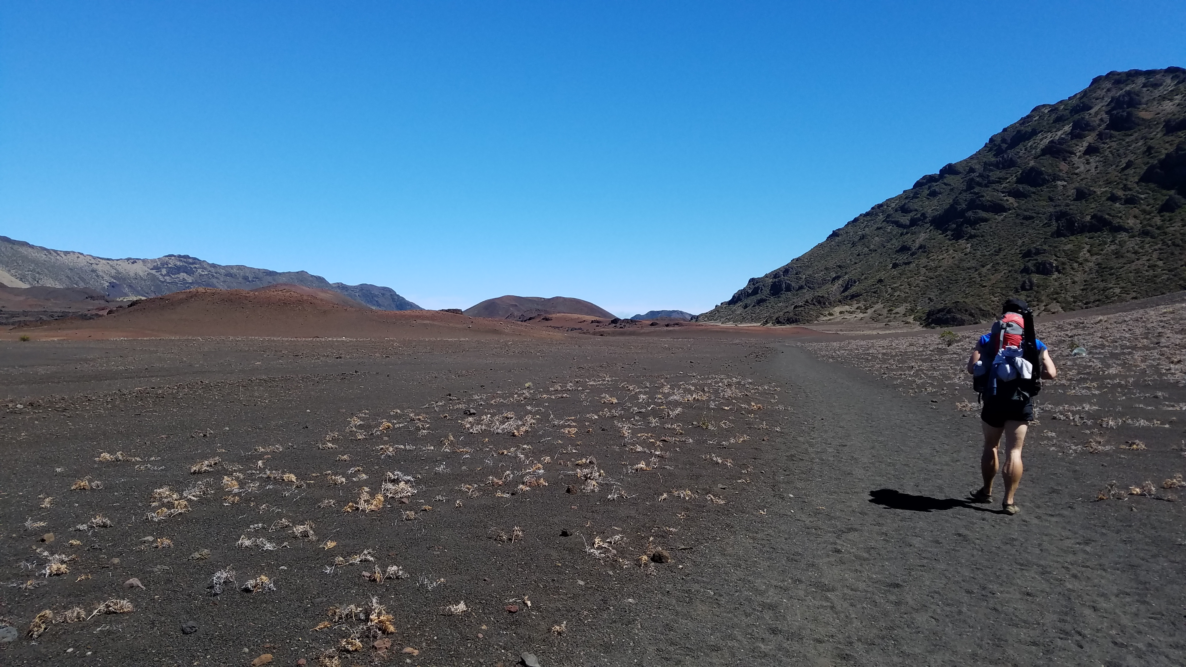
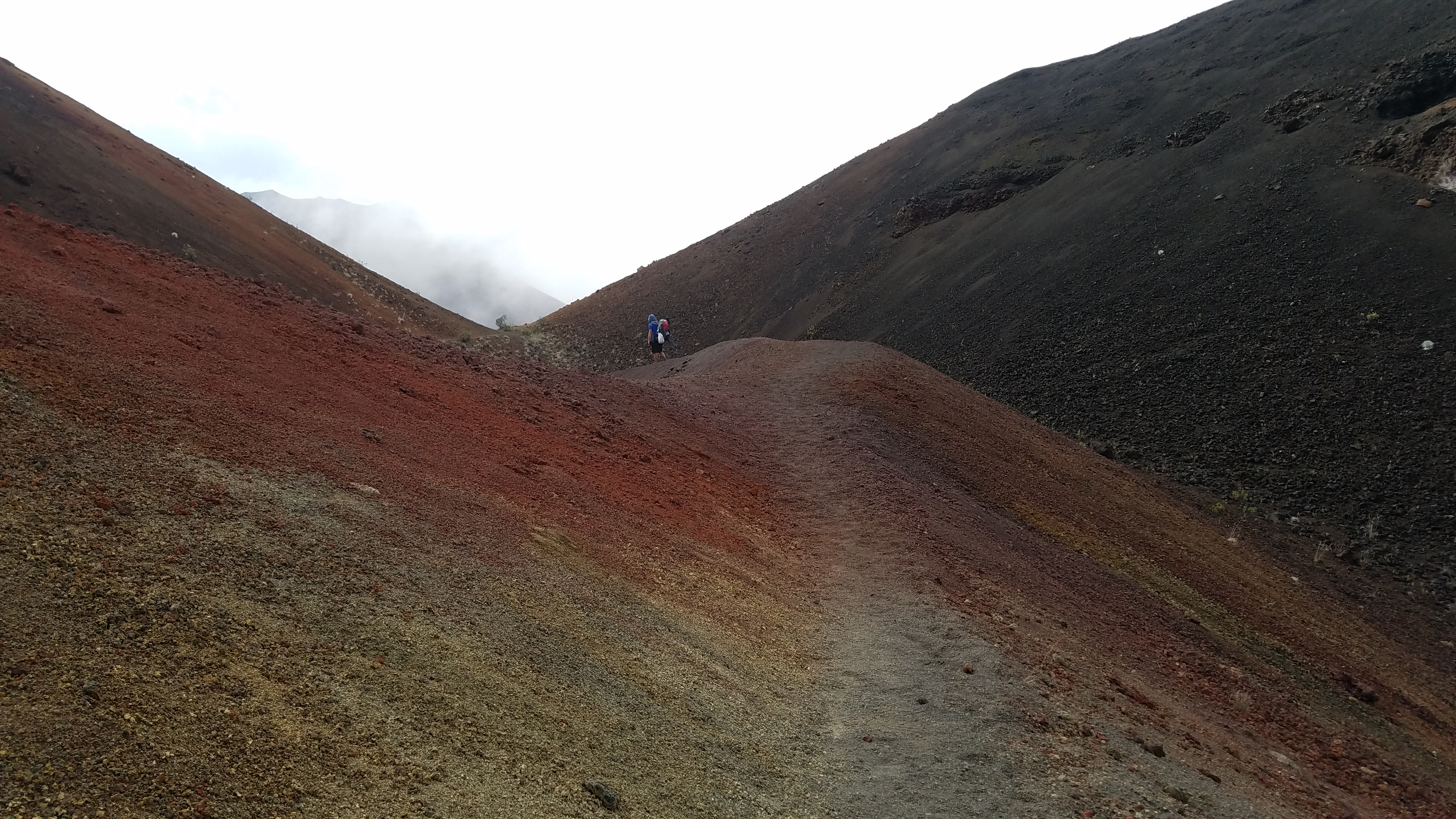
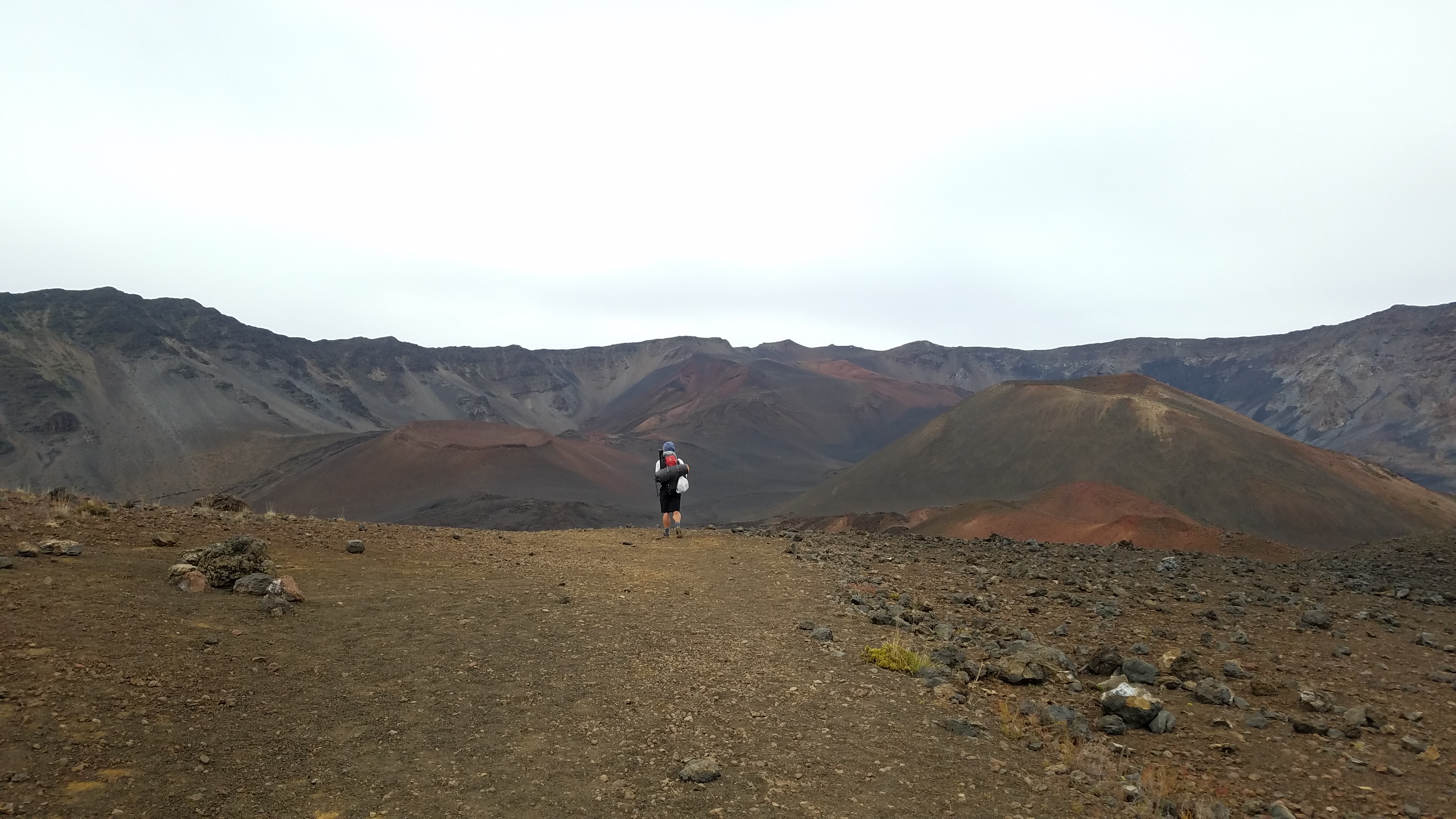
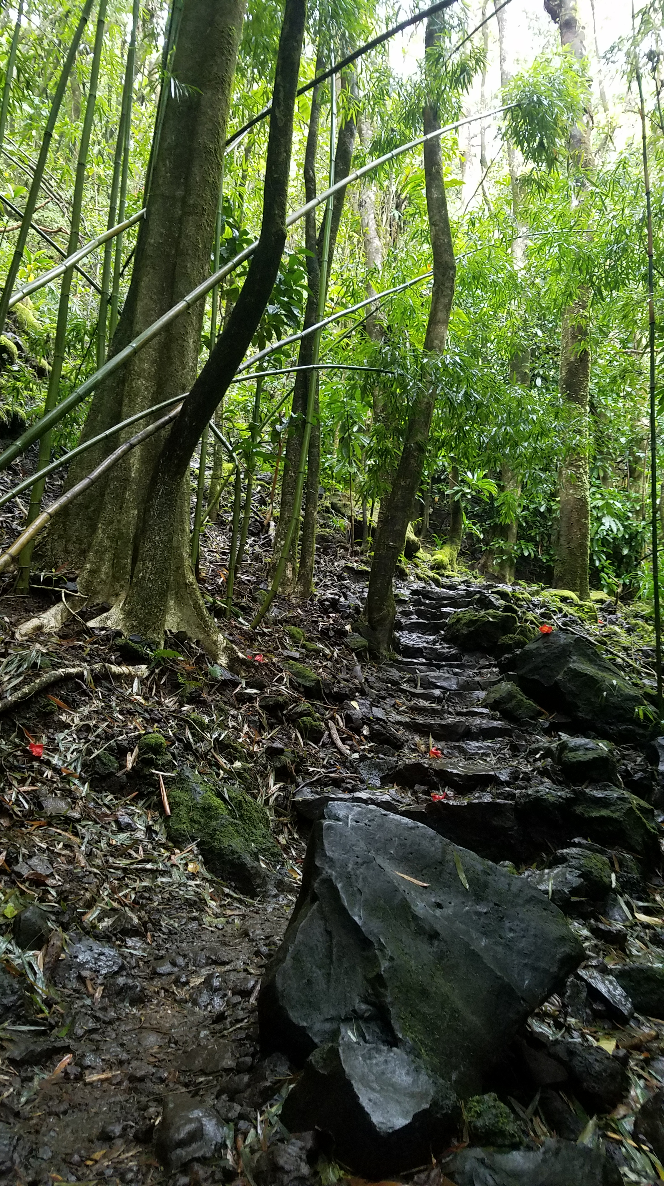
Day 1 of this hike isn’t necessarily hard, just long and brutal on the knees, ~10.5-11mi. The first few miles are flat and slightly up as you crest the ridge that looks over the Grand Canyon of the Tuolumne. From there, you start the downhill slog to the bottom. We stopped at about 5 miles in to a nice rocky area that overlooks the canyon area and Hetch Hetchy. For the next 3 miles you’re doing switchbacks down to the bottom. If it seems like you’re almost done, you’re not. They really do keep going. If the sun is out, these switchbacks will feel like an oven. Luckily, we were treated to a summer thunderstorm about halfway down. The downpour was warm and last for about 20 minutes. By the time the rain started letting up, we had hit the bottom of the canyon. From there we started following the Tuolumne upstream and into Pate Valley. Pate Valley exists where the Piute Creek joins the Tuolumne River. Its a moderately forested area with several areas where people have camped previously. You can tell from the fire rings and sitting rocks. We actually received mixed information from the park rangers regarding campfires. Tioga Rd wilderness station said no fires. Tuolumne Meadows wilderness station said fires were okay. Evenings were a balmy 75 degrees so a campfire was not in the least what we wanted. Upon reaching the place we wanted to camp, we realized we were being watched by a black bear and her 2 cubs. This was the first time I’ve ever seen bear cubs. They were a good 50 yards away and skirted the edge of the area our campground was in and then disappeared into the woods. Pate Valley is known for the highest number of bear sightings in Yosemite.

20170819_094219

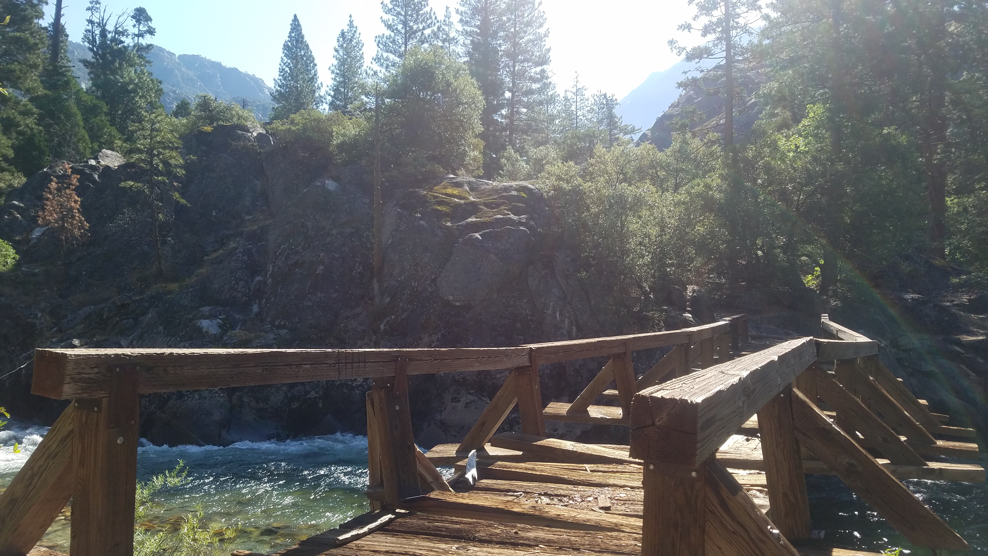
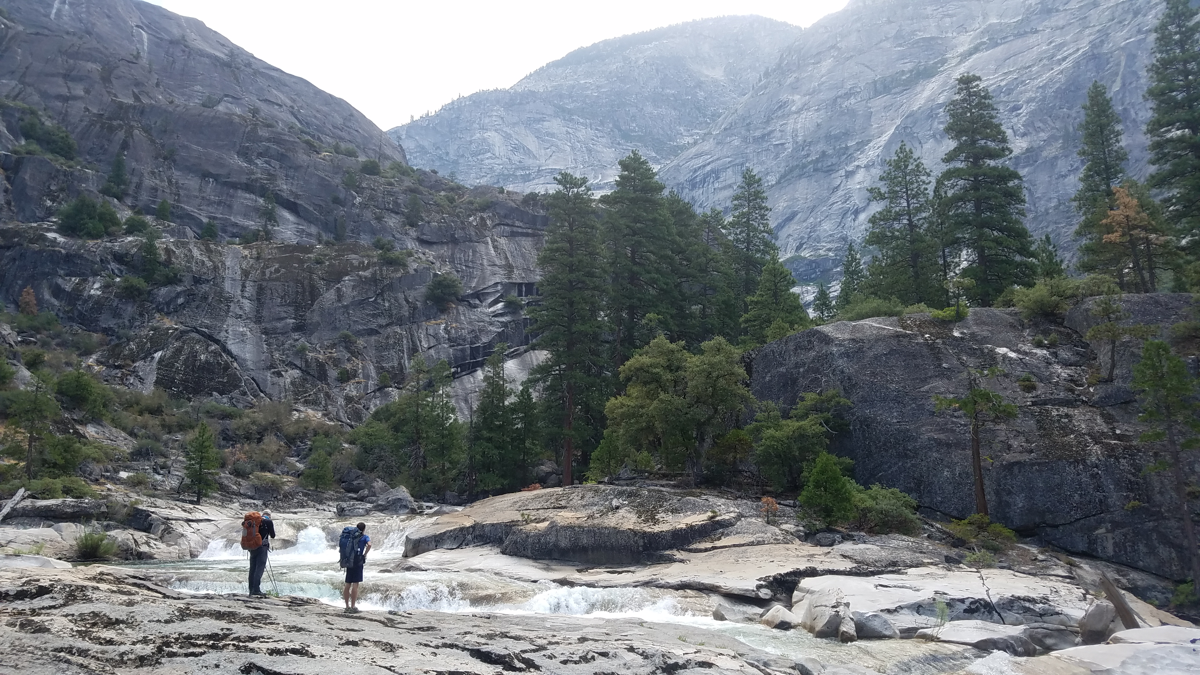
Day 2 started off with the temperature quickly ramping up early in the morning. After packing up camp, we decided to go for a quick swim before starting the 11mi day 2. There are 2 bridge crossings you do in order to follow the trail. The first bridge was still in tact but the second bridge was all but blown out from this year’s epic snow-melt. We received more conflicting advise on how to do the crossing. One ranger said don’t use the bridge, ford the river (which was actually pretty deep and running strong). Another ranger said use the bridge, just do so cautiously. We had talked to another group of hikers coming from the opposite direction and they said if you stick to the middle beam of the bridge we would be fine. So we did that and got across without any problems, but it sure looked janky.

20170819_100803

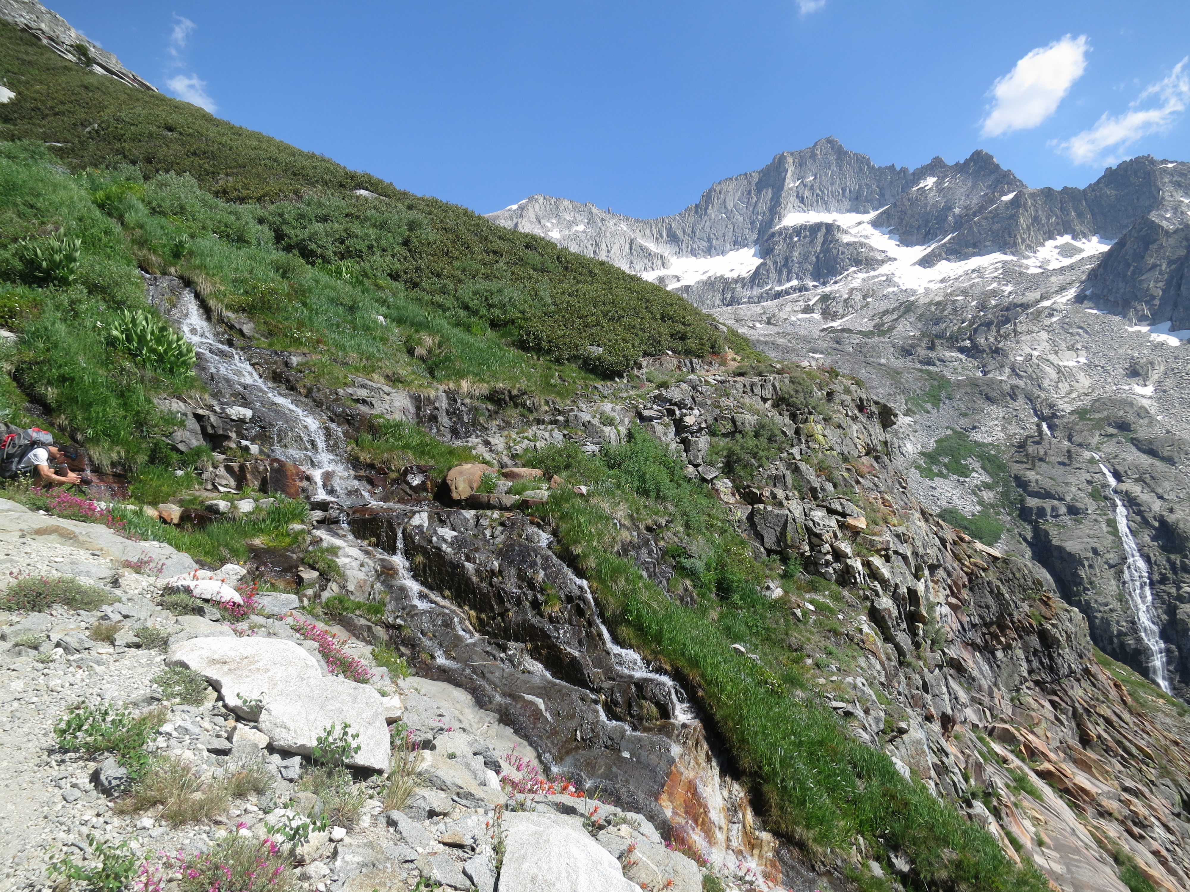
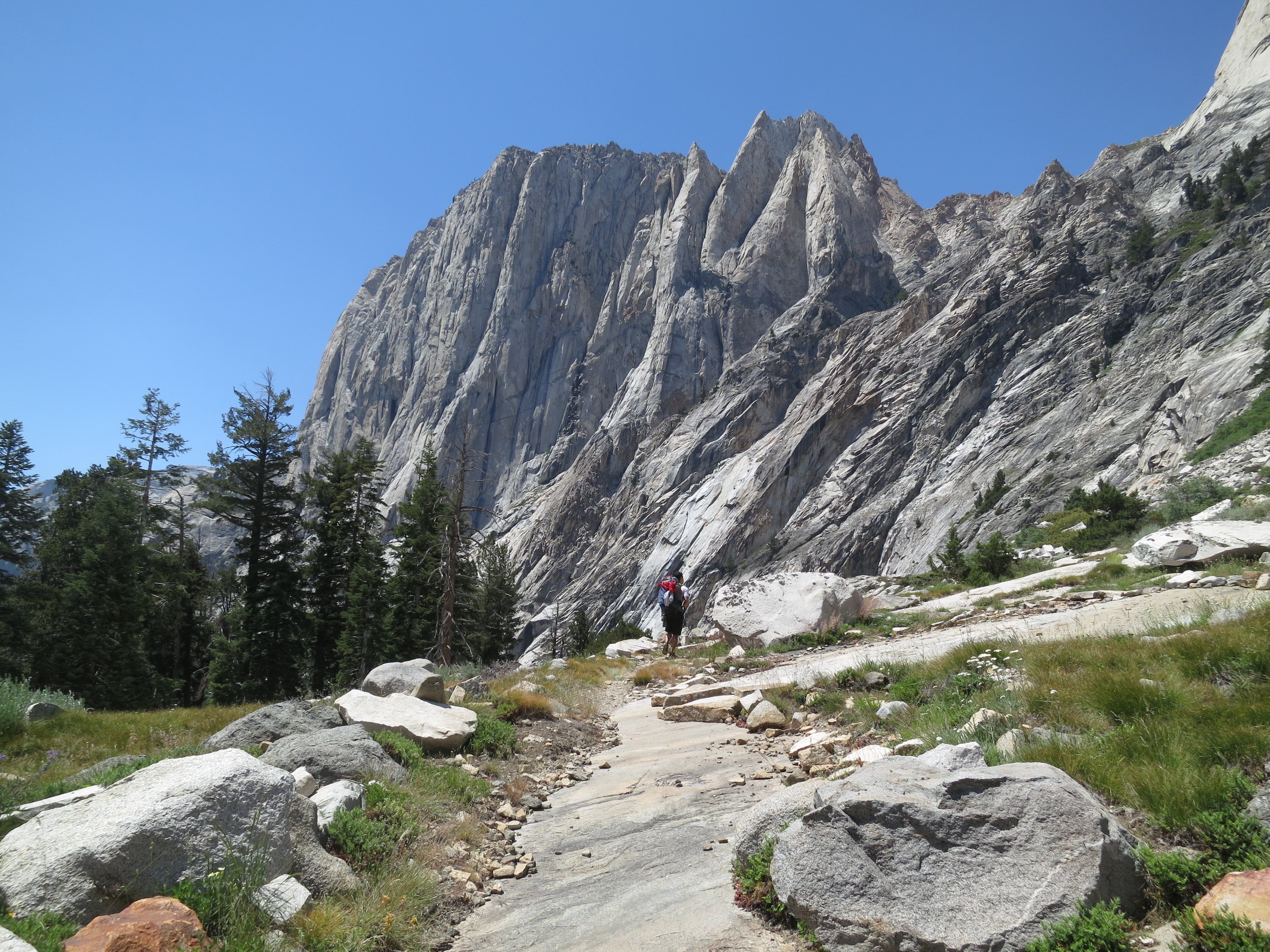
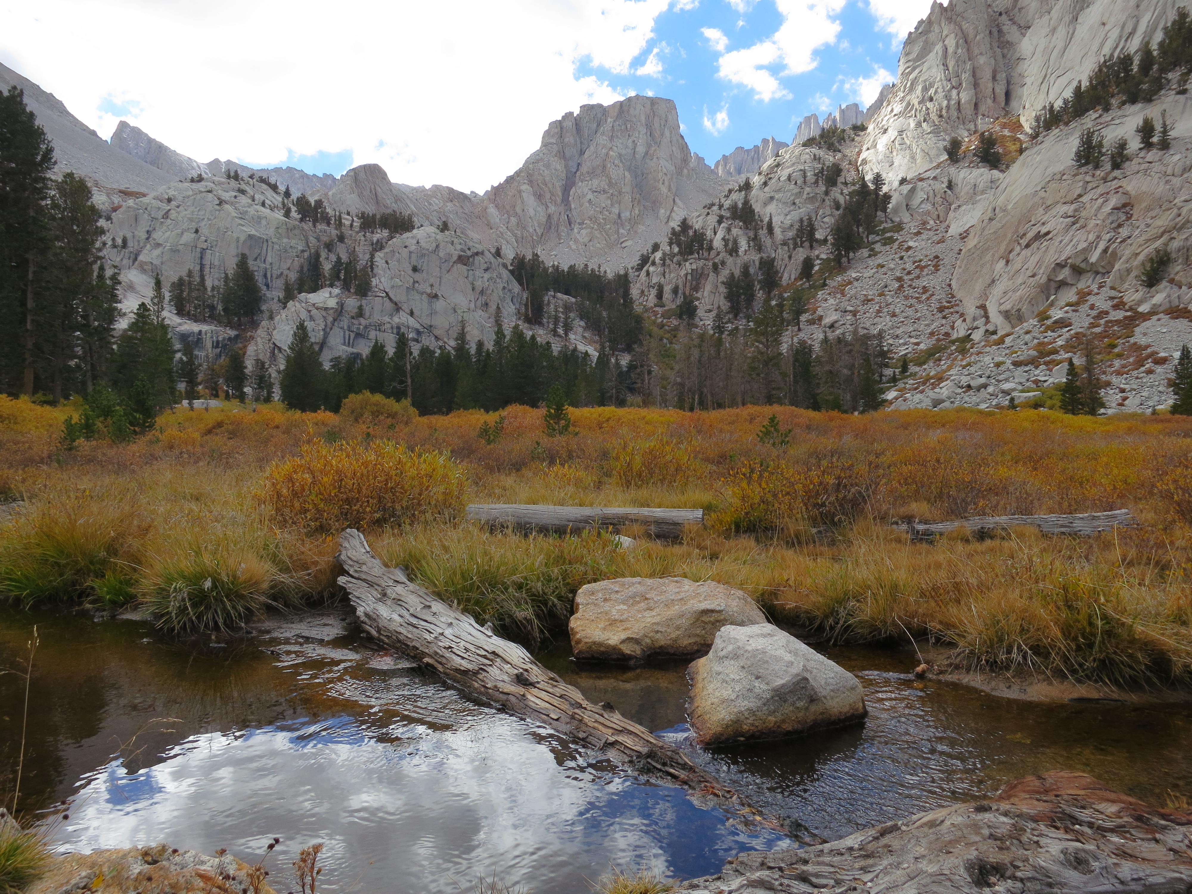
We probably spent too much time goofing off and swimming but it felt great at the time. It was going to be hot so it was nice to relish the cold river water while we could. Day 2 really felt like eternity. I was coming off being utterly sick and bed ridding a week before, so the heat, elevation gain, and mileage really took its toll. Not to mention the worst fly and mosquito area I have ever hiked through. Even with bug spray on I had to constantly swat away flies and straight up smash mosquitoes because they wouldn’t leave me alone. For me, this hike really fell into the type 2 category of fun. In the thick of it, its mostly just a mind game to get yourself to keep walking, how to ignore the bugs, the pain in my feet, and the exhaustion. Writing this now and looking back, I can’t wait to get out there again. The trail was really quite beautiful but at the time you just can’t enjoy it. Lush wooded areas, frequent waterfalls, amazing canyon views. I recommend taking a lot of pictures to enjoy later. My favorite thing about Yosemite are those massive granite walls. They are awe inspiring. There they have stood for millenia. They are timelessness. And who are we to stand among them? They always remind me of mortality. Yet at the same time, we are so small and are capable of scaling mountains in our blip of a lifetime. How amazing it is to be human.

20170819_110648

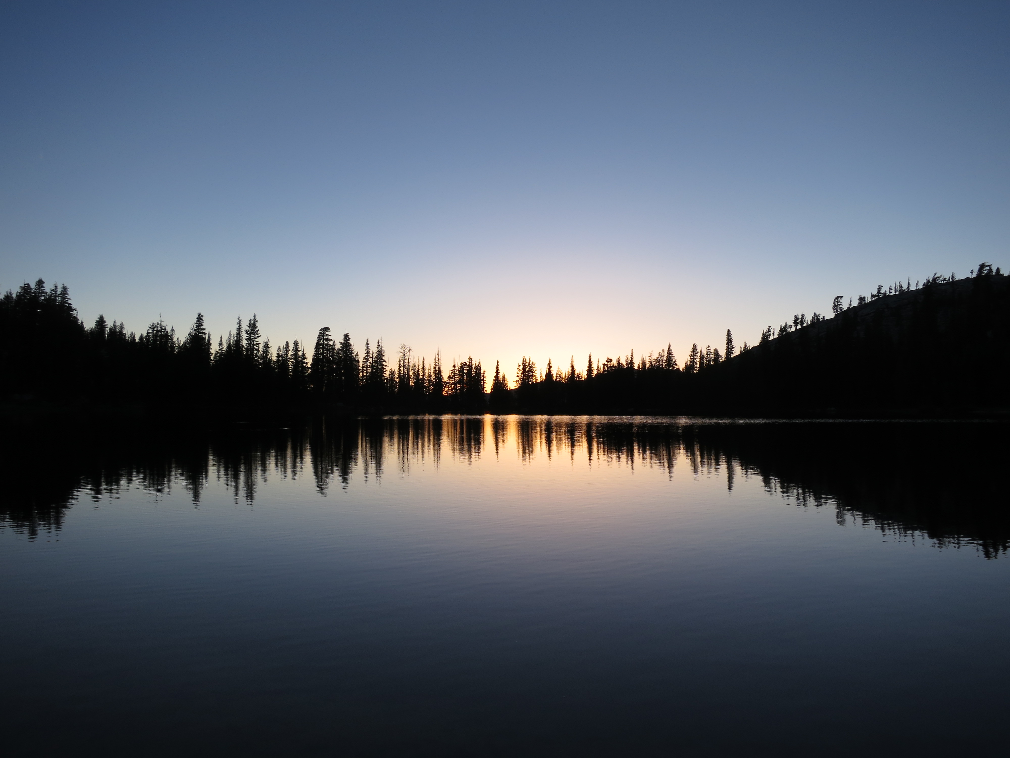
It was a long day, that about describes day 2. I’ve done higher mileage days before and this felt like the absolute longest (for whatever reason). We finished the final set of switchbacks up Water Wheel Falls just as the sun was setting, and topped it off with another bear sighting. Could not have been happier to have day 2 be over.

The day you hike out always has a bit of excitement to it. While I love backpacking, its nice to look forward to a shower and some In n Out. Day 3 is around 8-9 miles, depending on your map source. You continue up past Water Wheel to LeConte Falls and then onward to Glen Aulin High Sierra Camp. The camp was closed this year but the solar toilet was still open which a number of the group used. I was doing well up to about 2 miles pass Glen Aulin and then I totally tanked. My legs and feet wanted to be done. Luckily, the last few miles of the hike were more or less flat and on dirt trail. It still hurt terribly but its all a faint memory now. All I feel now is the satisfaction having done it and the joy of having spent a weekend out with my friends in one of the most beautiful places in the world.

Lake Aloha Out and Back

TL;DR

This late spring trip took us 6.5mi into Desolation Wilderness to Lake Aloha (which wasn’t quite a lake yet). Lake Aloha is a seasonal lake that forms from snowmelt accumulating in a granite basin. What we experienced was just tons of snow. Intermediate terrain allowed for us to brave the snow in hiking boots and snowshoes, although microspikes would have probably have been the optimal choice.

Permit Application Destination Zone: 33 Aloha

LakeAlohaTrailBeta

GPS Track and Elevation Data

Thoughts

Desolation Wilderness is one of the most popular wilderness areas in the state. I believe it. I didn’t even go very far in and it was breathtaking. All of that right off highway 50. I applied for permits as soon as I could not really considering the heavy snow year that California was having. I got permits for Memorial Day weekend and as the date got closer, realized that we were going to be doing some snowcamping.

The road to the trailhead wasn’t going to be plowed yet so we had to park at the Echo Lake SNOPARK, which is just a small parking lot with a bathroom. Permits for the SNOPARK can be bought and printed out here. Permits are good for any SNOPARK in California and Oregon so purchasing a permit doesn’t necessarily mean you’ll be guaranteed a spot. We were hiking in on a Friday so we beat the weekend crowds. The Echo Lake SNOPARK is almost a mile from the actual trailhead at Lower Echo Lake.

20170526_121550

As we hiked along the edge of the first Echo Lake, this hike soon became a test of mental integrity. Making sure each step on the snowy slopes was secure before pushing off really wears on you, especially with a pack on. 50 feet of snow, then 50 feet of trail was our reality for the first 2 miles. We got to the north end of the first Echo Lake and were starting to doubt we would actually make it to Lake Aloha before sunset. We had seen a group go ahead of us from the start so we pretty much followed their path. We were the second group to come through so we had to kick in a lot of the steps.

We made short of the upper Echo Lake and then Tamarack Lake and started the climb up to the pass. Now was when it become pure will power to drudge up the snowy slopes. Its been a long time since I’ve had a leg work out like that. Having to work your quads in addition to the stabilizers in your leg working overtime was rough. It was a slog, pure and simple. Its times like these when I’m reminded that, pass a certain point, you either end up shutting off your brain and just taking step after step, or you brute force it until the end. This is why I am weary of taking friends on their first backpacking trip. Sometimes there’s trails where are all you can do is drudge on and I can’t say its fun. Getting to the destination is fun. 20170526_164610
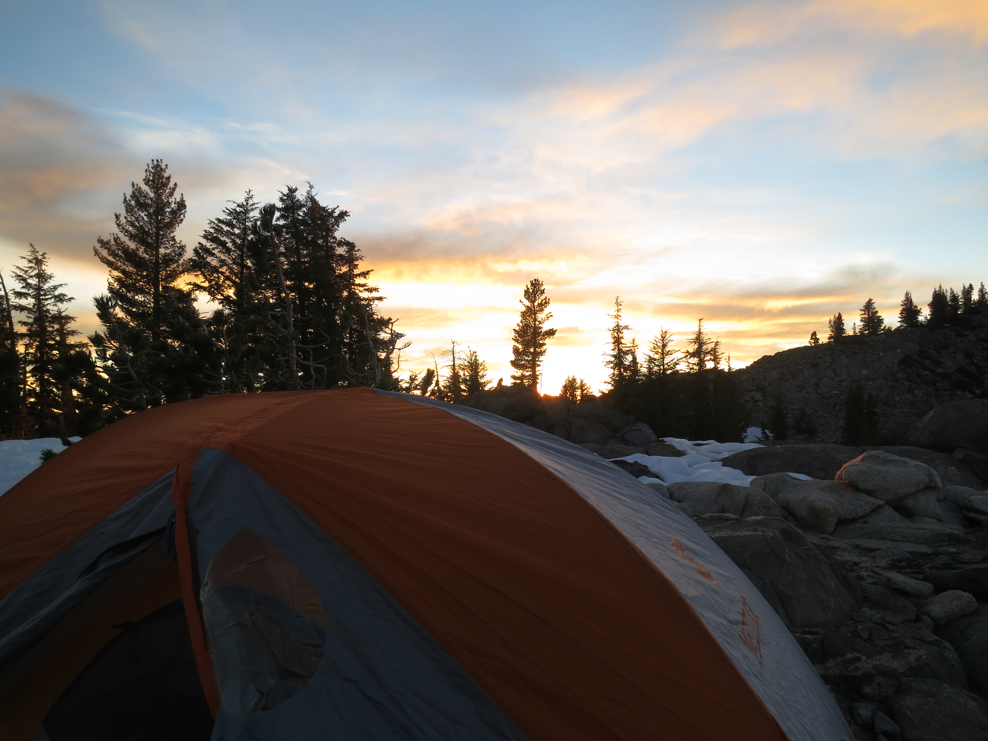
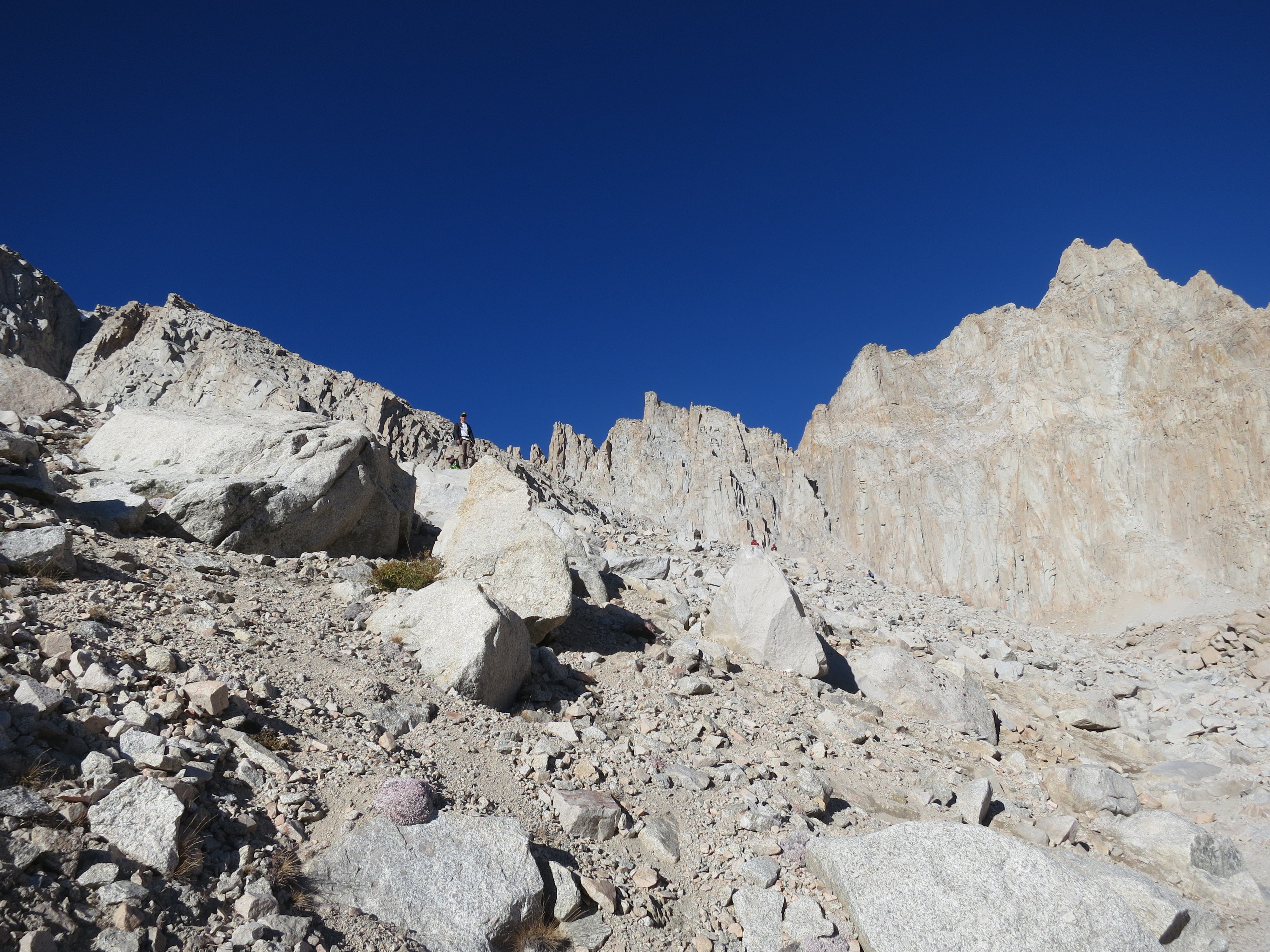
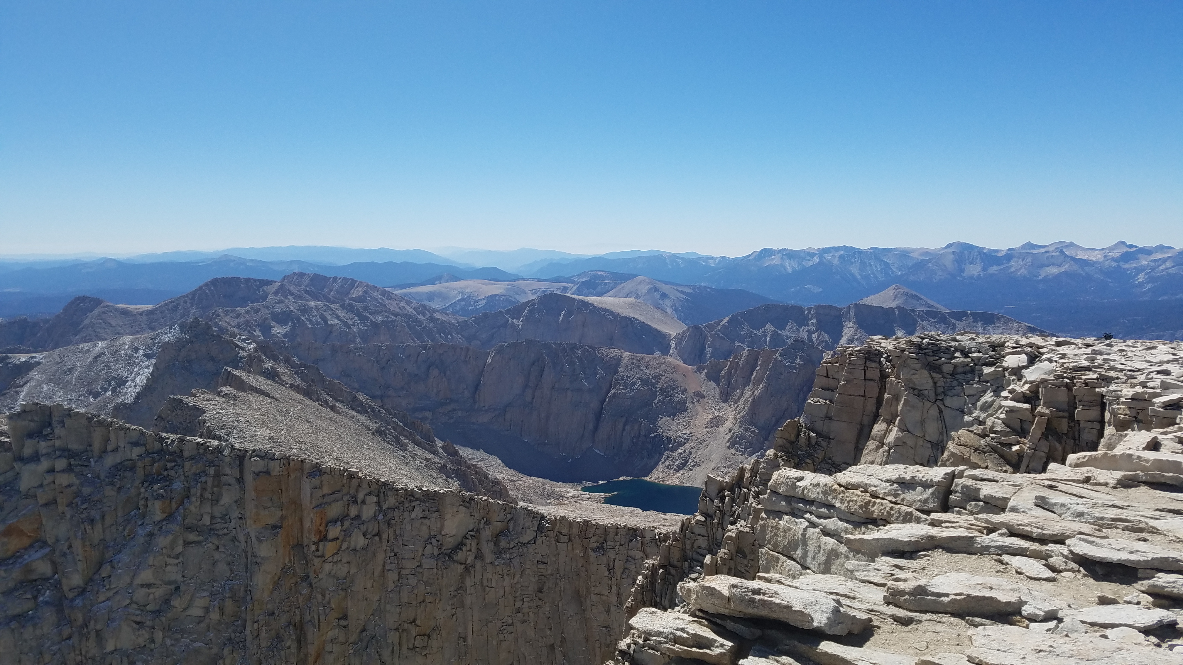
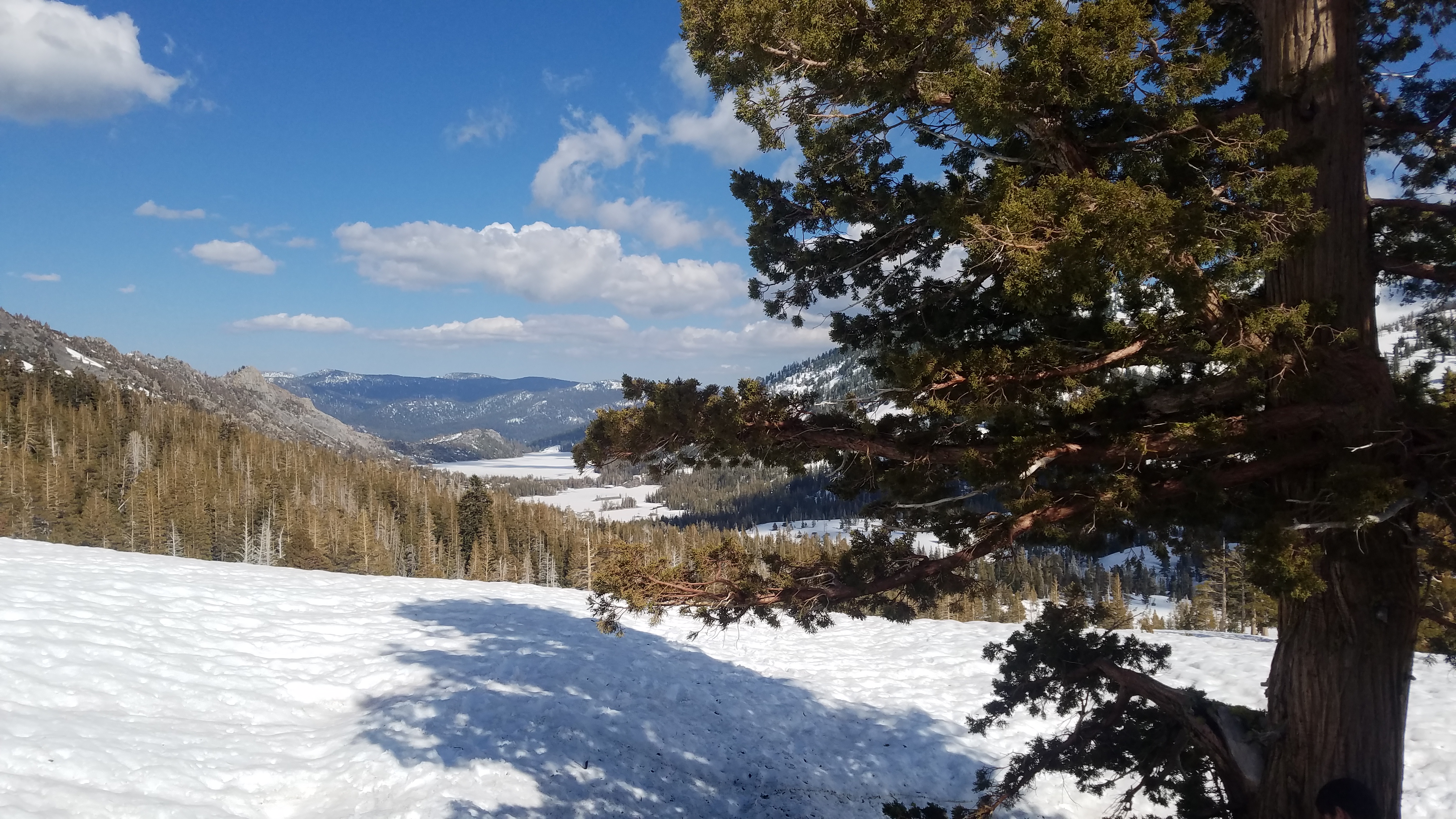
Forcing yourself to take the next step is not. But perhaps in these times its not the pursuit of “fun” that is our reason to go outside (although I will argue that it is often times simply that) but to see how far we can push ourselves…to see how far our bodies will go and how far our mind can push it without giving up. I wouldn’t even say its character building…its more like character breaking to reduce yourself to robot that just takes step after step up a frozen hill. Its also a bit unsettling to know that despite how far you are able to push yourself, you still have to do that all again to go back home.

20170526_194451
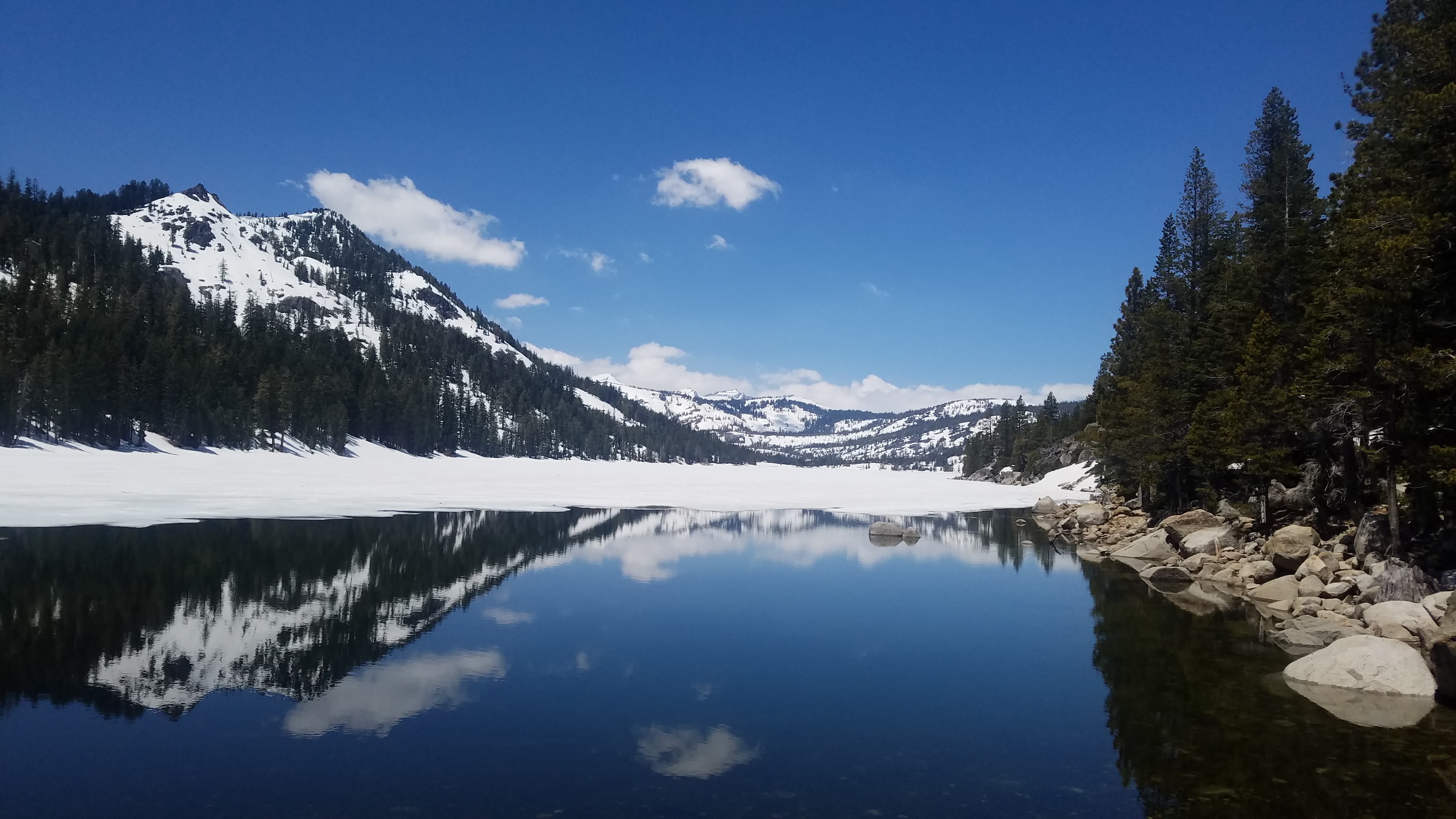
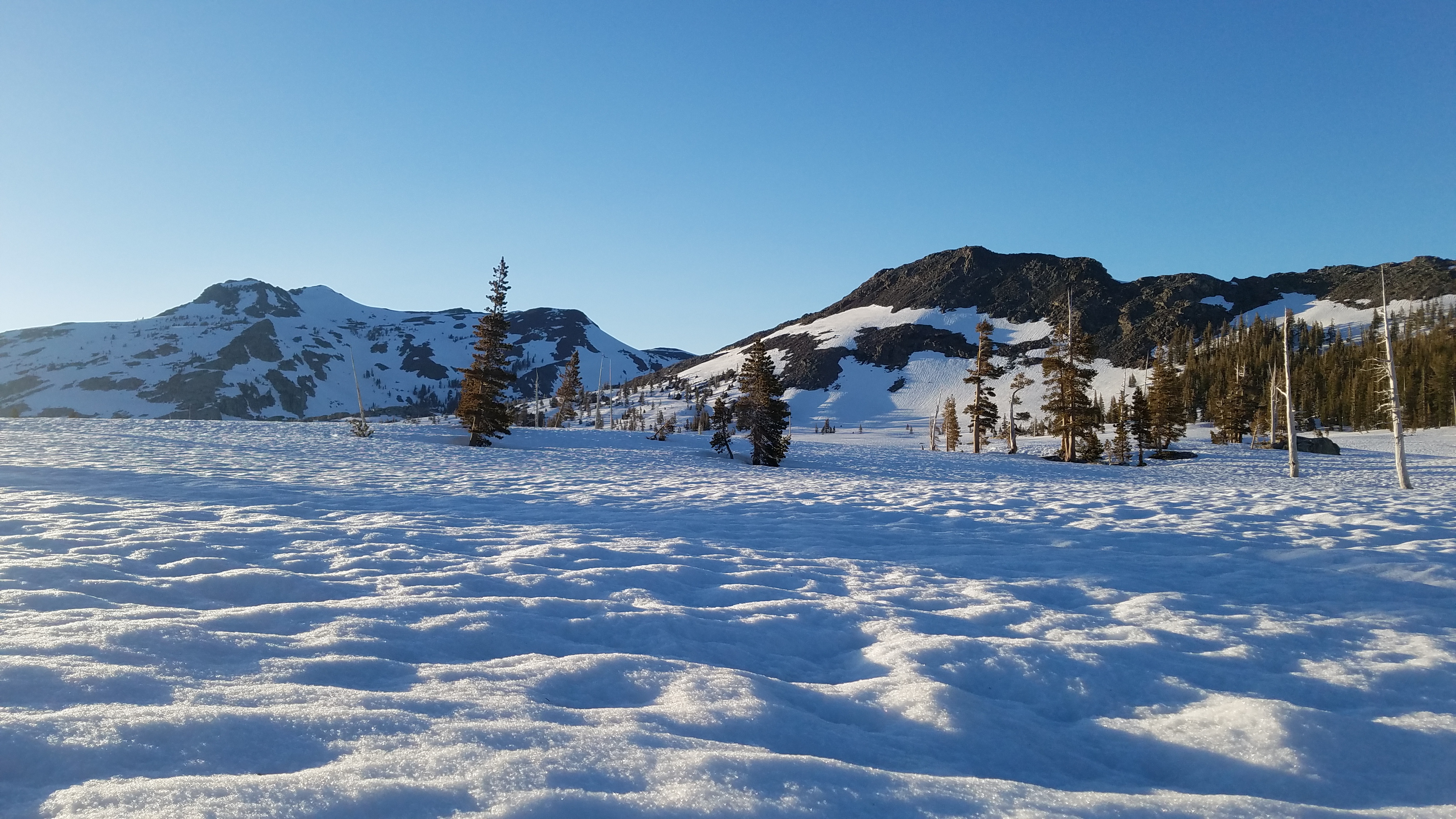
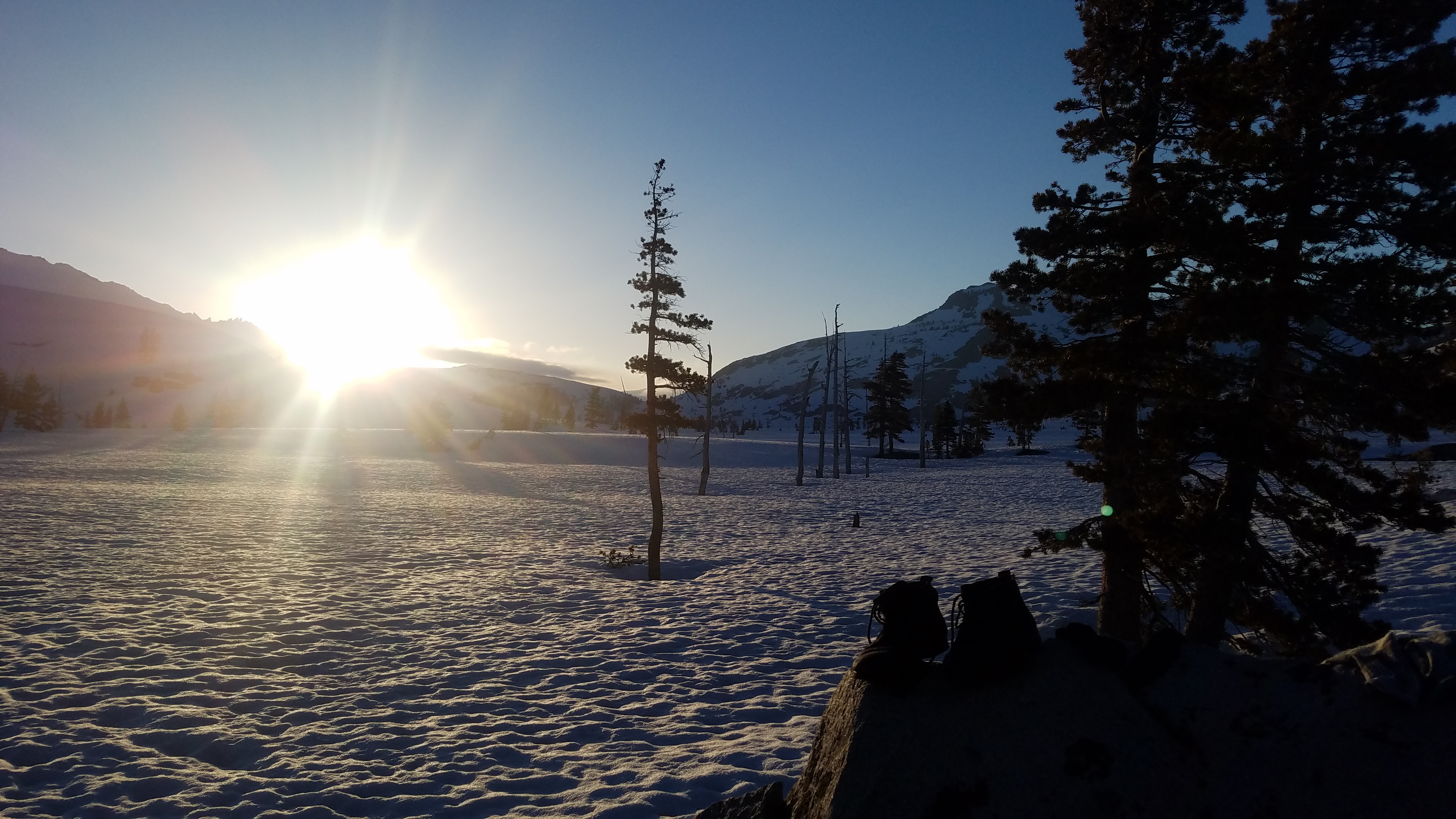
Alas, there was a light at the end of the tunnel. We made it to what GPS said was Lake Aloha before sunset. What it really looked like was a giant snowfield. We happened to find a nice grouping of rocks to setup camp so we wouldn’t be completely in the snow. The group that was ahead up us camped up on a rocky ridge that jutted out into the “lake” but otherwise there was no one else around.

Our plan was to do 2 nights at Lake Aloha. Spend a day exploring, then the hike back the next. Although we were pretty beat and didn’t feel like doing much exploring. The other group we saw packed up pretty early and left. So we took it upon ourselves to see what was up on that ridge and also see if we could find any water, melting snow was taking too long. The weather was perfect, not a cloud in the sky, and low 60s. 20170527_130736
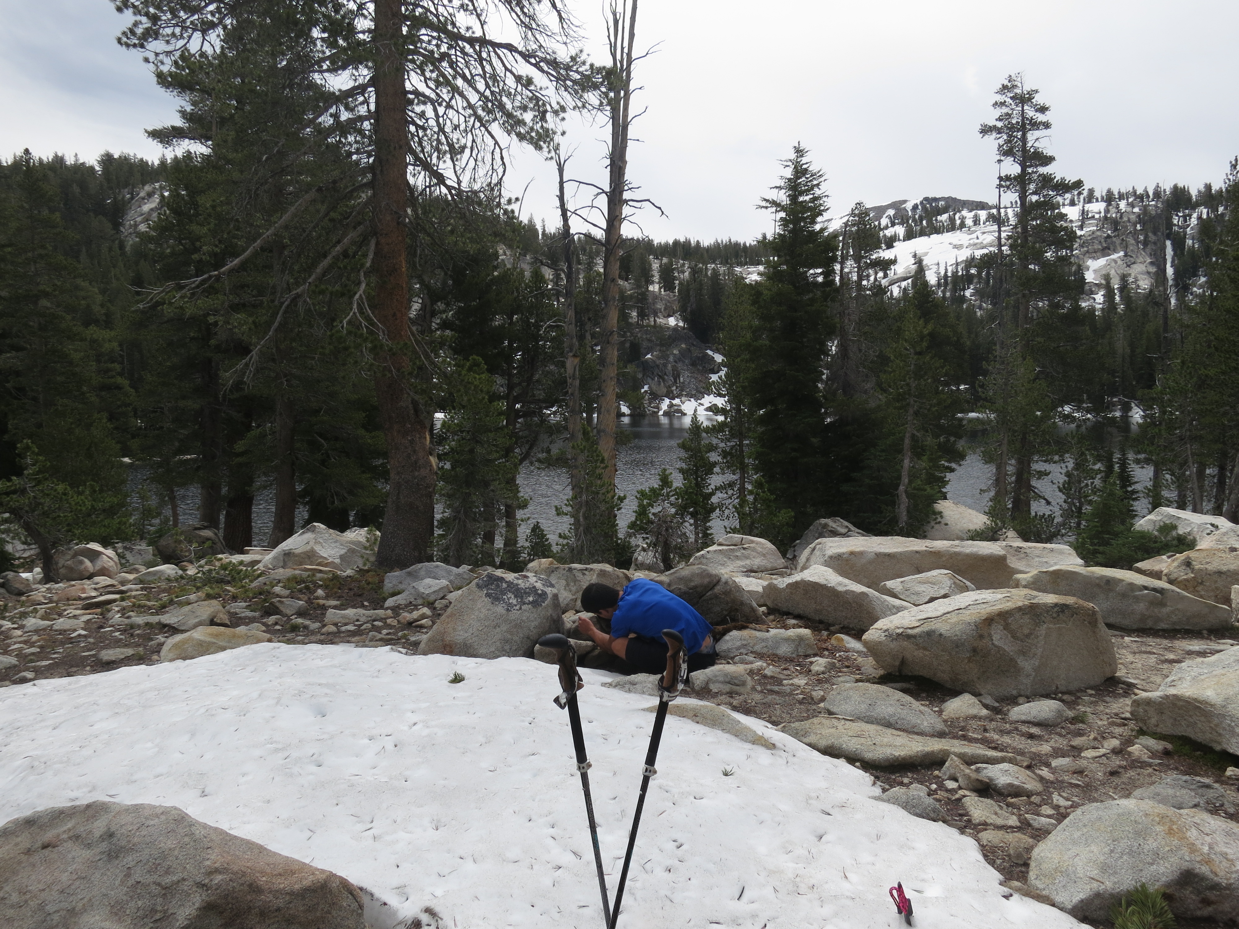
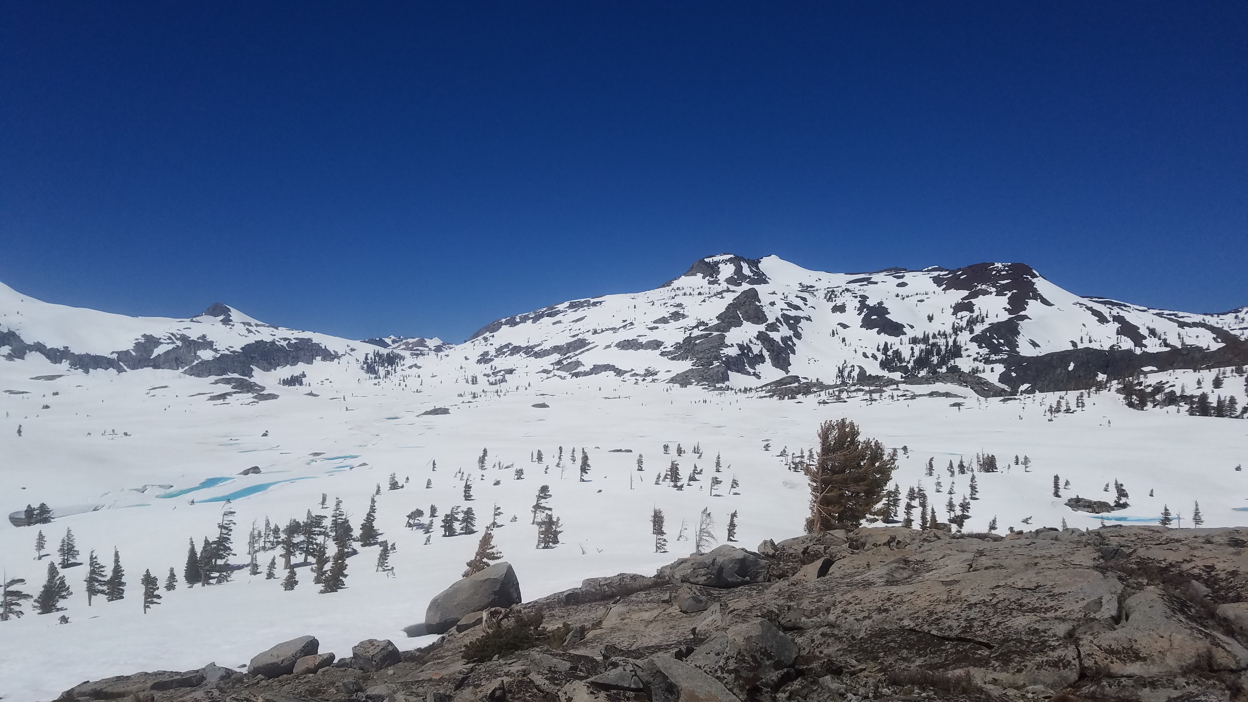
With the sun reflecting off the snow it felt more like low 80s. We got up on the ridge and looked around. There were a sporadic amount of small snowmelt lakes forming and to the west was an actual stream. We hiked down off the ridge to check it out. Apparently there was an actual dam release there. It was a bit sketchy because you can’t really tell what you’re standing on until you can see it from the water’s side. All we could tell that at some point there was a supported cement wall, so we aimed for that wall.

20170527_134414

The refilled our water stash at one of the snowmelt ponds since they were liquid again by afternoon. We spent the rest of the day reading and relaxing since it became too hot to really want to do anything else. The pros of backpacking in May is that you get some epically long days. Its such a joy to cook and eat dinner before sunset. Since it starting cooling off, we walked around a bit more and got some photos of the sunset.

The hike back out the next day went smoother than expected. The snow was a bet slushier because of the warm weather, and the trail was much more warn in from the people that came in on Saturday and Sunday. Nothing like what we experienced on Friday. Its funny how in the moment, things can be so excruciating and hard, yet days later the memory of it is so much fainter. Your legs are no longer burning, your heart is no longer pounding. You’re no longer hating life. How quickly all that effort fades away. Something to remember, and even more reason, to push myself again.

20170527_193508

Cathedral Lakes Backpacking

TL:DR

You don’t have to go very far to see some pristine high sierra lakes and epic sunsets. We did this 12.6 mile thru hike over 3 days/ 2 nights with plenty of time to take in the scenery, relax, and do some day hike exploring. You will either have to shuttle cars, hitchhike, or catch the Tioga Rd Shuttle to do this thru hike. You start at Tenaya Lake and end at Tuolumne Meadows. Main points of interest on this hike are the Sunrise Lakes, Sunrise High Sierra Camp, Cathedral Peak and Cathedral Lakes.

You can apply for permits up to 24 weeks in advance.

CathedralTrailBeta

Thoughts

This is a retroactive post. I did this trip before I started this blog but its one worth mentioning. We did this trip back in June of 2014. Thinking back, we did this hike pretty early in the season. If California wasn’t in a drought we probably would’ve been caught up in some snow. I first saw Cathedral Peak when I was on a prior trip, hiking up Mt Hoffmann. There’s just something about its outline against the sky and its name that just stuck in my mind as somewhere I wanted to go. Names have power, or so they say. Luckily, a few of our friends also wanted to do that hike so we applied for the permits and made it happen.

This hike breaches the 9000ft elevation mark so if you’re susceptible to altitude sickness you might opt to do one night at one of the campgrounds on Tioga Road to start acclimating. One of our friend’s is, so we drove down to Yosemite late Thursday night to get one night in before the hike. I didn’t start camping and backpacking until I was in grad school so I think this was my 4th time backpacking ever. Now that I think about it, I can’t believe that trip was only 12 miles…and over 3 days no less. Its cool to be able and look back and see actual progress and an increase in efficiency. We do 12 mile days now and while its still tiring, we think nothing of it. But for being so short, we saw some pretty amazing scenery.

IMG_0217

Day 1 is ridiculously short (~3mi) and starts off at the Tenaya Lake/ Sunrise Lakes trailhead. It also has the most elevation gain so maybe its for the best. The whole day is more or less switchbacks and uphill. This is the same trail you would take for Cloud’s Rest which I also recommend. This trail gets a lot of afternoon sun exposure and can get quite hot. There are also no water sources on this section of the hike so its recommended to start early. There will be a fork on the trail, going right takes you to Cloud’s Rest while going left will take you to Sunrise Lakes which is wear we continued on to. There are three Sunrise lakes, all of them beautiful and look great for swimming. It wasn’t quite warm enough for us to go swimming but I imagine in the late summer it would be perfect.

IMG_0222
IMG_0243

We set up camp around the third Sunrise Lake with plenty of time to wander around and play on the boulders. Small patches up snow were still around with everything else being pretty marshy. Some guys were on the other side of the lake fishing but otherwise we didn’t see too many people. Its hard to pin down the feeling I get backpacking. I think it might just be excitement though. No matter where I am, its the same feeling so its hard to bring novelty to the way I describe the places I’ve been other than physical appearance. Being out there is beautiful, inspiring, refreshing, meditative, and it never gets old. It never loses its impact and I find it literally insane that people go their whole lives without ever wondering what’s out there. Its like a breathe of fresh air for the soul…and I need it. The soul needs excitement.

We hung out, made dinner and enjoyed the sunset. I’m not sure why they’re called the Sunrise Lakes, but sunset was spectacular.

IMG_0260
IMG_0284
IMG_0286

Temperatures plummeted during the night and our nalgenes froze. But once the sun was up, it quickly became suffocating inside our tents. Day 2 was a little longer coming in at ~6 miles. From Sunrise Lakes we hiked past the Sunrise High Sierra Camp. We went to go check it out but nothing was set up yet and no one was around. Everything was bogged down from all the snow melt so for the next few miles, we were in a constant state of mosquito attack. Once we started up toward Cathedral Pass, the mosquito swarms eased up. Came across quite a few deer who probably scared us more than we scared them. This section of the trail is sort of along a ridge. The whole time I was just looking out for that signature outline of Cathedral Peak.

When you first come over the pass, everything kind of opens up. You see Cathedral Peak as well as Upper Cathedral Lake. Our goal was to set up camp at the lower Cathedral Lake which sits more at the base of the peak. Its another mile or so pass the upper lake but it was pretty amazing to finally be there and see it. The trail leading down to the lower lake just kind of disappeared, perhaps from all the mud. We were essentially just trekking straight across a bog until we got to the granite perimeter of the lower lake. Depending on the water flow, you can walk around the perimeter with a brief water crossing where the lake dumps into Teneya Lake. We hiked counterclockwise around to the northern shore and set up camp. The sunset and corresponding alpenglow were pretty stunning that night as was the star gazing but I don’t have a good enough camera for that. Just take my word for it.

DCIM100GOPRO

We were hiking out on Day 3 but not before we did a quick scramble up the short peak on the south edge of the lake. We were in hiking boots with zero climbing gear, it was a relatively low key scramble but gave you a stunning view of the lake and peak on the opposite side. Day 3 was a nice 3 mile downhill meandering to Tuolumne Meadows. On the way out you’ll encounter a lot of day hikers heading for the Cathedral Lakes. If you don’t have time for the backpacking portion you can always make it a day hike.

IMG_0332

Sliding Sands to Halemau’u Loop

TL;DR

Haleakalā National Park resides on the Hawaiian island of Maui. Haleakalā NP is split into two parts, the summit and Kipahulu districts. The summit area is a vast dry volcanic landscape where we did our 2.5 day/2 night 25 mile backpacking loop. The Kipahulu district resides on the south eastern slope of Haleakalā. In contrast, its a lush environment full of trees, bamboo forests, and waterfalls. Our backpacking trip started from the Slidings Sands Trailhead near the summit, journeyed to Paliku camp, Holua camp, and back. Permits can be obtained, for free, from the visitor center up to a day before entry. Reserving permits in advance is not an option. Check with the visitor center to make sure the water catches at the campgrounds are functional. The summit of Haleakala is at 10,023ft. Acclimation may be required. Even though this is Maui, it does occasionally drop below freezing at night. We hiked

*Note: We did not stay at the backcountry cabins. Those require reservations far in advance.

Haleakala-Loop

GPS Track and Elevation Data

Overview

Have you ever wondered what it would be like on Mars? Wonder no further, because you’re a plane ticket away from being able to experience it yourself. Volcanic red and black sand extends for miles. The cinder cones peppering the eroded crater floor. If you’re near Holua you might find yourself immersed in a cloud, making the surrounding crags of lava rock like some forlorn wasteland. There weren’t too many other hikers or backpackers that came across our path. With no trees or large animals in the arid area of the park you are left alone in silence. Not even the wind can make a sound.

Our journey began at the Sliding Sands trail head near the summit. There are technically 3 trailheads you can take to enter Haleakala Crater; Sliding Sands, Halemau’u, and Kaupo. Sliding Sands and Halemau’u are located directly off the main road that goes to the summit. The Kaupo trailhead is actually on private land off highway 31 and requires a pick-up/drop-off or hitchhiking. We went with the Sliding Sands partially for convenience (you can leave a car there) but also because you’re treated to the most amazing view as you descend into the crater.

20170223_115155

Haleakala is a dormant volcano. The crater that you hike through is due to weathering and not a collapse like other volcanic craters. Haleakala means “House of the sun”. The legend goes that the sun god would sleep within the crater, tired from racing across the sky. The demigod Maui and his mother lived on a neighboring island. His mother lamented that the sun moved too quickly and that she never had enough time to finish her work during the day. Hearing this, Maui climbed to the top of Haleakala and waited for the sun to begin his day. As the first rays of sun light appeared, Maui jumped out and lassoed the sun and tied him to a tree. The sun pleaded to be released but Maui would not let go. Maui told the sun to promise to move more slowly across the sky and then he would let him go. The sun relented and was released. Maui rushed home to tell his mother the good news, and sure enough she was able to finish all her work before sunset.

20170223_131542

Like most places of lore, you can immediately see why they considered this a sacred place. As the clouds surround the crater, as it happens on most days, you almost feel like you’re in a world removed. An island floating in the sky. Haleakala isn’t a very large park, but once you descend to the crater floor (~2500ft) it starts to appear pretty vast. Those cinder cones that you saw from the top are now miles apart and several hundred feet above you. You can see the various trails go off toward their own vanishing point, no trees to block your view.

20170223_163503

Our first day took us from Sliding Sands to the Paliku backcountry camp (9.5mi) nestled in the east end of the crater. Over the course of those 9.5 miles you go from a volcanic arid landscape to a lush green grassland full of birds and the indigenous nene goose. We actually lucked out and got to see several families of nene and their babies. We were forewarned that the nene will be a little more aggressive since they have their babies with them. If they sense you’re a danger, they’ll start to hiss at you. If you stand still they eventually ignore you but if you run they’ll proceed to chase which can be quite scary. Paliku has one of the 3 cabins you can rent in addition to a handful of established campsites interspersed in the tall grass. The only ones back there were use, 2 park rangers, and one other tent. Its in these moments that I find it so funny that we say how small the world has grown. Its only small when viewed through a computer screen. Once you’re actually out there, its really quite vast and lonely.

20170223_163538
20170224_120454

Day 2 arrived and we were treated to some crunchy frozen grass at our campsite. Temperatures during the winter can dip below freezing during the night. I would say the temperature range was similar to spring/early summer in the sierras. We carried pretty much the same gear that we take to Yosemite (3 season tent, 20F sleeping bags, puffies, etc). For day 2 we were hiking from Paliku, up the Halemau’u trail to Holua camp. We said goodbye to the nene and set off. The hike took us along the opposite side (north) of the crater from Sliding Sands (south). We watched as the grass and shrubs disappeared as we reacquainted ourselves with the volcanic sand peppered with silver sword. Silver sword looks like a metallic succulent but is apparently part of the daisy family? (The more you know). Its only found in Haleakala above 6,900ft only adding to the alien like appearance of the surrounding area. Its classified as a threatened species as it only grows in Haleakala and on Mauna Kea on the Big Island.

If you noticed on the map of the hike that there’s a short detour we took way of trail, I’d recommend not doing that. While there are other detour hikes that sound cool and worth doing (crystal caves, alternate view points) this was not one of them. Around the Kawilinau pit there’s a sign that says “Unmaintained Trail” next to something that looks like any other trail in the park. It doesn’t really lead anywhere. We followed it out about a mile and ended up at a dead end on a steep drop-off. Not knowing where else to go or seeing a safe way down we turned back to the main trail defeated.

20170224_122331
20170224_140938

Once back on the main trail, fatigue setting end, we found ourselves heading into the clouds.
The Halemau’u trail heads out of the crater to the Halemau’u trailhead.
This section of the crater doesn’t have the high walls to keep out the clouds. The trail winds through a few of the smaller cinder cones. The ranger giving out permits said to be sure to go this way because its notably beautiful. So we kept our eyes peeled for something “notably beautiful” as cryptic as that was and I think we did stumble upon it. While the majority of the landscape is rust colored and black volcanic sand, there was one slope of one cincder cone that had a myriad of colors. Reds, yellows, and greens dusted the side of the cinder cone. And as suddenly as it appeared it was gone. So keep your eyes peeled around Kawilinau or else you might miss it.

20170224_142554

It became increasingly more overcast as we continued our hike. We eventually hit the fork where you can continue on to Holua or head back toward Sliding Sands. We saw a pair of day hikers but they quickly outpaced us. Heading toward Holua was heading straight into the cloud. With nothing visible except the dark rocks within a 30ft radius things got eerie pretty quickly. The continued on for some time. It was hard to tell how much further we had to go until camp without being able to get a sense of our bearings. Eventually we saw the Holua cabin come into view. The Holua camp sites are up the hill to the left of the cabin. The camp sites were small flat spots dispersed around a rocky outcropping. With no one to be seen we chose one that had a descent wind break and set up camp. Not too long after the clouds suddenly cleared up and we were shocked to see that were actually right up against the crater wall.

IMG_2094

Day 3 came and we woke up to our tent being totally covered in frost. We were hoping for a nice sunrise ( Holua faces east) but it was a bit too cloudy to see anything. On a clear day you’d be treated to Haleakala’s noteworthy sunrises. It was our hike out day. We had two options either hike back out Sliding Sands (~7mi) to where our car was, or continue hiking out the Halemau’u trail (~4mi) but then have to hitchhike back to the upper parking lot. We elected to go the longer route. If we were going to do switchbacks, we preferred to do them to the car and not have the intermediate step. The hike back to sliding sands was pretty amazing. You could see all of what you had to hike to get back out laid out before you. Not sure if that was more disheartening or awe-inspiring…or maybe perplexing since you don’t normally see that while hiking. Nonetheless it was great to be able to see those fantastic views of the crater the whole way back. So happy and blessed to have the chance to do this hike.

20170225_103122

Bonus

20170227_100348

As I mentioned before there are two districts to Haleakala, the summit and Kipahulu. After our backpacking trip we took the road to Hana around the island making a couple stops here and there. If you have the time, a visit to Hana is pretty amazing. Its very lush and tropical and has beautiful beaches and great food. One of those nights we spent at Kipahulu and then did a short hike the next day to 400ft Waimoku falls. If you have time this hike is beautiful. It starts down by the coast and follows the Pipiwai stream up to Waimoku falls (~4 miles round trip). Towards the middle of the hike is a dense bamboo forest that is so tall it blocks most of the sunlight. A huge contrast to the arid landscape of the summit district, yet all in the same park!

Mt Whitney Trail

TL;DR

Play permit roulette in order to score the chance to backpack to the top of California or if you’re feeling bold, Whitney-In-a-Day. We spent 3 days, 2 nights in the beauty of the eastern Sierras to do this 22 mile round trip hike.

mtwhitneytrailbeta

Thoughts

Well here it is, the tallest peak in the contiguous United States. Its sort of weird, you get all hyped applying for permits months and months in advance, planning the trip and then you just wait. Then the day finally comes to put your shoes on and haul your backpack up the trail and you’re like “Whoa, I’m doing this”. I know I’ve mentioned this feeling before but it really does get me every time. This year we were lucky enough to be awarded lottery permits for a 2 night backpacking trip on Whitney in late September. Its tough getting overnight permits for this hike. A fantastic overview of the permit process as well as the hike itself can be found over at Modern Hiker. We applied for a smattering of different dates and ended up with the last weekend in September which was optimal. Summers are prone to afternoon thunderstorms making the top out dangerous while early spring can be wet or covered in snow.

Permits need to be picked up from the Eastern Sierra Interagency Visitor Center in Lone Pine either the day before or day of entry onto the trail. Whitney Portal campground is a good base-camp if you are able to pick-up the permits the day before. Its about a 20-30 minute drive between the two. Its also good if you don’t handle altitude well. Lone Pine sits at ~4000ft whereas Whitney Portal is at 8,300ft. A night there could help with acclimating before pushing on to the two other camps or the summit. We were planning on staying in Whitney Portal the night before but didn’t make it to Lone Pine until 2 in the morning. D had forgot his sleeping pad so we opted for a motel. The next morning we picked up the permits. They also give you WAG bags since all waste must be carried out. Luckily, we found out the other person in our group had a spare sleeping pad. Note to self, maybe pack extra sleeping pads just in case. Just thinking about how awful the trip would’ve been for D had he not had a sleeping pad made us grimace.

20160930_123947

Leading up to the hike, we were constantly monitoring the weather. We found that Mountain Forecast gave us the best data we needed to make decisions. Notably, the wind speeds and temperature vs altitude helped us plan how we would break up our 3 days of hiking. We were starting on Friday morning, hiking out Sunday afternoon. Wind speeds were picking up and temperatures dropping starting Saturday evening so we aimed for a Saturday summit. 3 of the 4 in our group had gone to Peru and done the Inca Trail while the 4th had a lot of high altitude backpacking experience so we felt like we could handle the hike to the 12,000ft Trail Camp and then summit the next day. From the Whitney Portal trail-head it’s 6.2mi basically all uphill (~3700ft gain). But it’s a very beautiful uphill, especially with the fall colors we got to see.

***SPOILERS BELOW, YOU’VE BEEN WARNED***

20160930_140028

The eastern Sierras rise up so suddenly compared to the western side. You can really feel their size as they dominate one side of the landscape. Despite being a trail with an ungodly amount of switchbacks, it has its moments that make you just say ‘Wow’. Lone Pine Lake stands abnormally bright blue against the brown of the White range and Lone Pine area. It looks like it was poorly photoshopped into place. But it really looks like that. From the moment you begin hiking, the granite mountains tower over you like giants. The trail meanders through several meadows that simply take your breathe away. A midst everything in this world, here is a small portion left untouched except for a small trail that skirts the edge of a creek. Its quiet except for the sound of running water. I love these moments. I feel like such an invader, an interrupter. Here in this tranquil place, I am the unnatural occurrence, yet to find these places and be in them for a brief amount of time is why I love hiking. Its a weird contradiction.

img_2074
img_2078
img_2079

3.8 miles from the trailhead is the first backcountry camp, Outpost (~10,365ft). We had just eaten lunch and felt relatively good. Outpost camp is a gravelly stream bank covered by some scattered shrubs and a fair amount of shade. Water was plentiful even though it was late in the season. It had only taken us a few hours to get to Outpost so it was early in the day. With no altitude effects yet, we decided to continue on to Trail Camp. 6.3 miles from the trailhead is Trail Camp (~12,000ft). While Outpost camp was on the fringe of a meadow, Trail Camp was a bit more desolate looking. With no natural vegetation, each of the camp sites have built up rock wall wind breaks. Trail Camp sits at the base of the notorious 100 switchbacks. The lake at Trail Camp hadn’t dried up so we were able to refill water and make dinner. From Trail Camp you can still see out to Lone Pine while also sitting in the shadow of Whitney and its fellow peaks. Its quite a sight to be at the base of them all the while thinking “I have a ways to go”. After setting up camp and eating dinner all of a sudden I felt queasy and decided to drink a bunch of water and go to sleep. The temperatures tanked that night making the following morning one of the coldest I’ve ever experienced camping. Weather estimates were saying it was going to be around 18-25 deg F and it sure did feel like it. We got a late start by hiking standards. Most of the campers had left for the summit by the time we got moving. We were leaving most of our gear at camp, only taking food and water in day packs. Even though the sun was out, the air was still frigid. This was the first time that I hiked in my thermal/puffy/windbreaker + fleece tights and was still slightly cold. I made slow work of the switchbacks. I hate gasping for air at altitude, it makes me feel panicky. But if I go slow, I never lose my breathe and can keep the same pace without stopping. Passed several groups along the way who had to stop. The sun had yet to melt the snow on the cables so that area was frozen solid. Walking on the ice was dicey to say the least. That’s what happens when something melts and refreezes overnight. D later told me the trick was to walk along the edge where the cable posts are mounting. Even though you’re on the edge, its actually easier since there isn’t any ice and you can grab on the cables directly. A couple fugue states later at we were at the trail crest.The trail crest marks the top of the switchbacks and the boundary between Inyo National Forest and Sequoia National Park. The trail also crosses over from the east side to the west side of the range. We took a short break then continued to push on.

img_2084
20161001_123924

Now, on the other side of trail crest is a sign that says “Mt Whitney 1.9mi”. Maybe it was the altitude, or we were tired, or both but this felt like the most utter lie I have ever been told. We continued hiking for what seemed like a whole day. The sun beat down hard with the cold wind drying out your skin. All you know is that there is granite everywhere and that Mt Whitney is somewhere on this meandering trail through granite rubble. The western side of the crest just looks like slopes of rock fall, all peaks sort of losing their shape. We trudged onward, seeing more and more people heading back down from the summit. What makes it hard is that, despite being a peak, you don’t really see your destination. I caught a glimpse of the hut at the top once, but never saw it again until I was actually in front of it. You just kind of meander for a while and then eventually pop out on top. And what satisfaction is it to see that little hot and the summit register with its appropriately placed “That was Easy” button. The day was clear despite the wind so we hung around the summit for  a while, eating some lunch and taking pictures. Mt Whitney may be the tallest mountain in the continental US but all the surrounding peaks are pretty darn close. It doesn’t have that regalness that Mt Rainier has. There was a cool Backpacker magazine article about how simply identifying mountains by their summit altitude can be misleading since the base altitude can vary greatly. Some mountains you can drive up most of the way whereas other you have to hike for miles before reaching the top because you start as almost sea level. The Mt Whitney hike is hard but definitely not the hardest.

20161001_123934

We felt pretty chipper heading back down. We got to the base of Mt Whitney’s nextdoor neighbor, Keeler Needle and D decided he was going for it. So 3 of our group of 4 dropped our packs and began the scramble up the backside of the needle. Somehow the altitude didn’t feel like a thing anymore. Plus the scrambling was a change from the trudging we had been doing all day. Keeler Needle isn’t for the faint of heart. There isn’t a trail, you just climb up big boulders. On either side are shear drops that look like they go back down to where Trail Camp is. It gets narrower and narrower until you’re at the last piece at the end. D and V went out to the edge but I did not have that much faith in my bouldering ability 3000ft off the ground. It was pretty cool to look sideways at Whitney though. Plus we were the only ones up there.

20161001_135213

We made good time going back down. The sun had passed over the crest so the east side was in shade and it was getting cold, fast. We got to trail camp, packed up camp and got out of there. Fatigue was setting in so going back down was a bit hard for me. We finally made it to Outpost Camp just as it was getting dark. We were just glad not to be camping at Trail Camp again. 10 degrees and 30-40 mph winds did not sound fun. Outpost camp was still cold but nothing we couldn’t deal with. We were still running on that sumitting high plus we had a warm meal and warm bags. We packed out the next morning, adding another adventure to the books.

Peru Part II: The Inca Trail

TL;DR

The Inca Trail is amazing, go do it.

Thoughts

Everything is awesome. Everything is stairs. Well, not everything. Probably 75% is stairs. I’m not even sure if I can articulate how amazing it is to be up in the Andes. This is coming from someone with zero mountaineer experience and who’s only spent time in the Sierras. But these were mountains. Glacier capped rugged mountains.

The Inca Trail or Camino Inka is a fantastic way to learn a little bit more about the Inca civilization, hike in the Andes, and ultimately see Machu Picchu. I wouldn’t have done it any other way. The only way you are allowed on the Inca Trail is with a guide which is understandable. Its a very popular route so reservations have to be made about~6 months in advance. The benefits of the guided hike is that they take care of all the permits and transportation, and in our case, provided porters to carry our stuff. Yup, we went glamping in the Andes. Not something we were used to, but more often than not, its how the Inca Trail is done it seems like. We had large group, 14 people, so having a private trek was cost effective. We used Enigma Peru as our trekking company and couldn’t be happier with their services and the wealth of knowledge of their guides. They made it fun and worry free.

img_1958
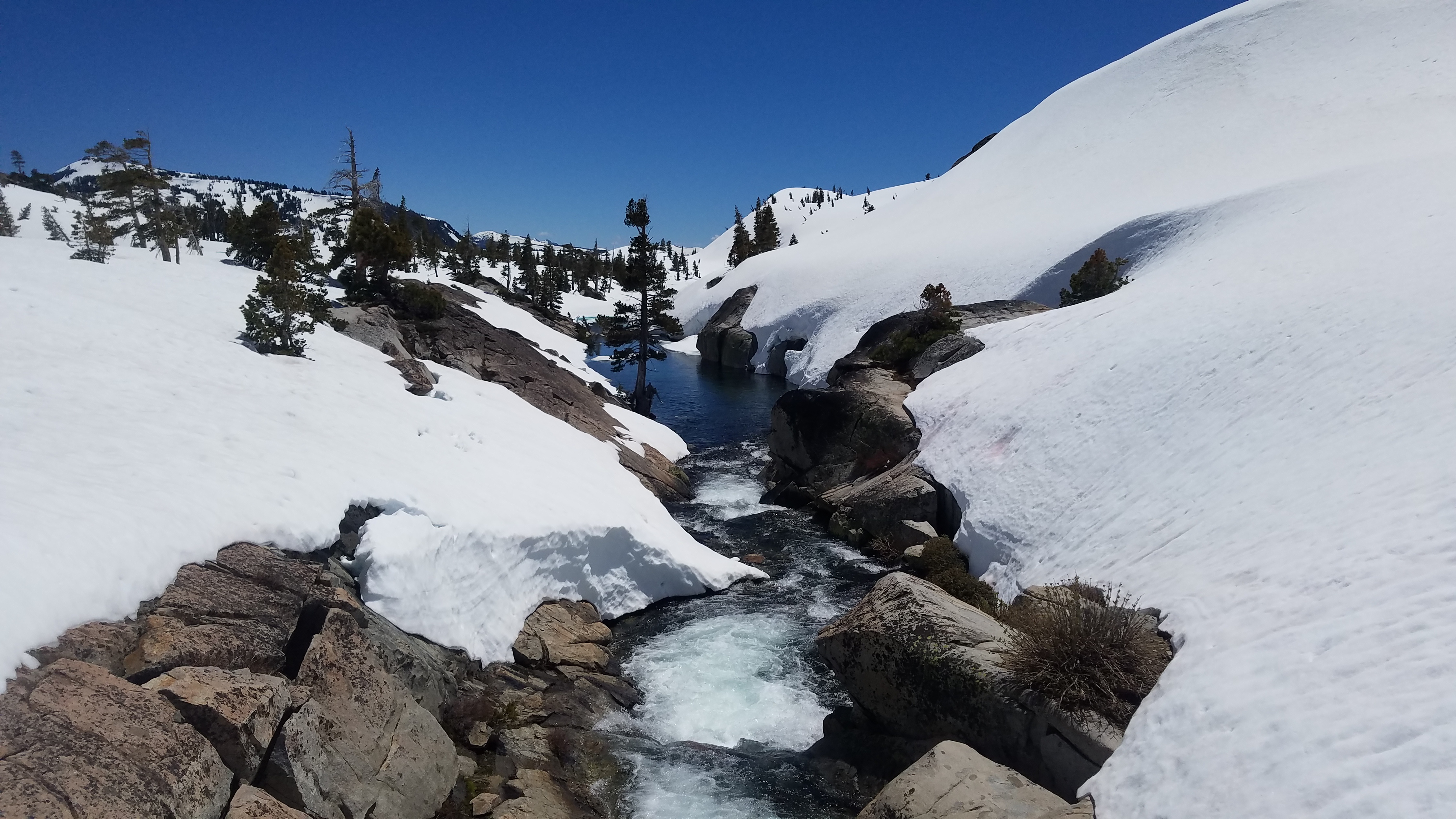
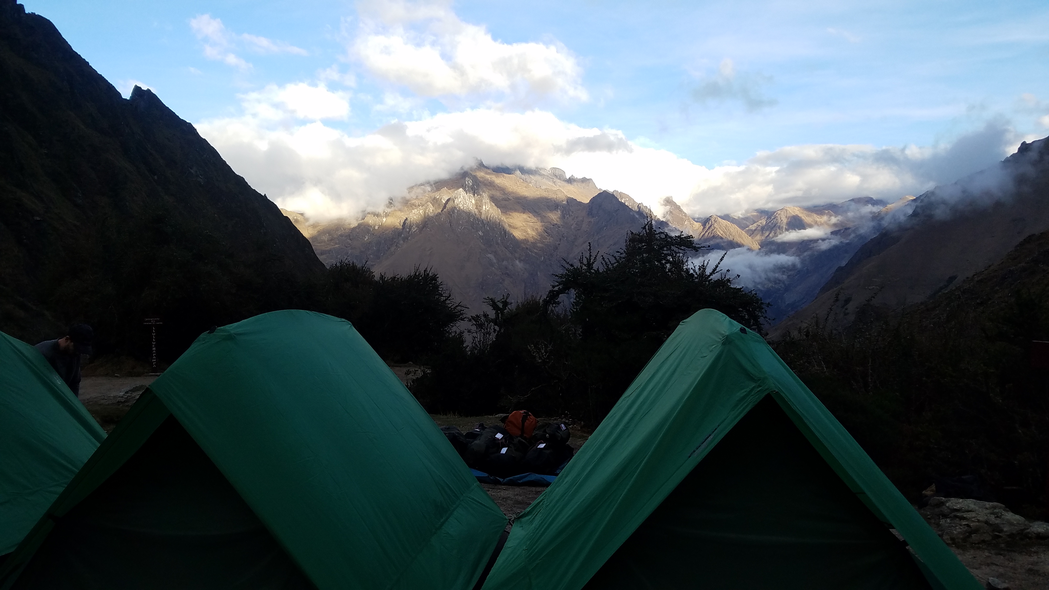
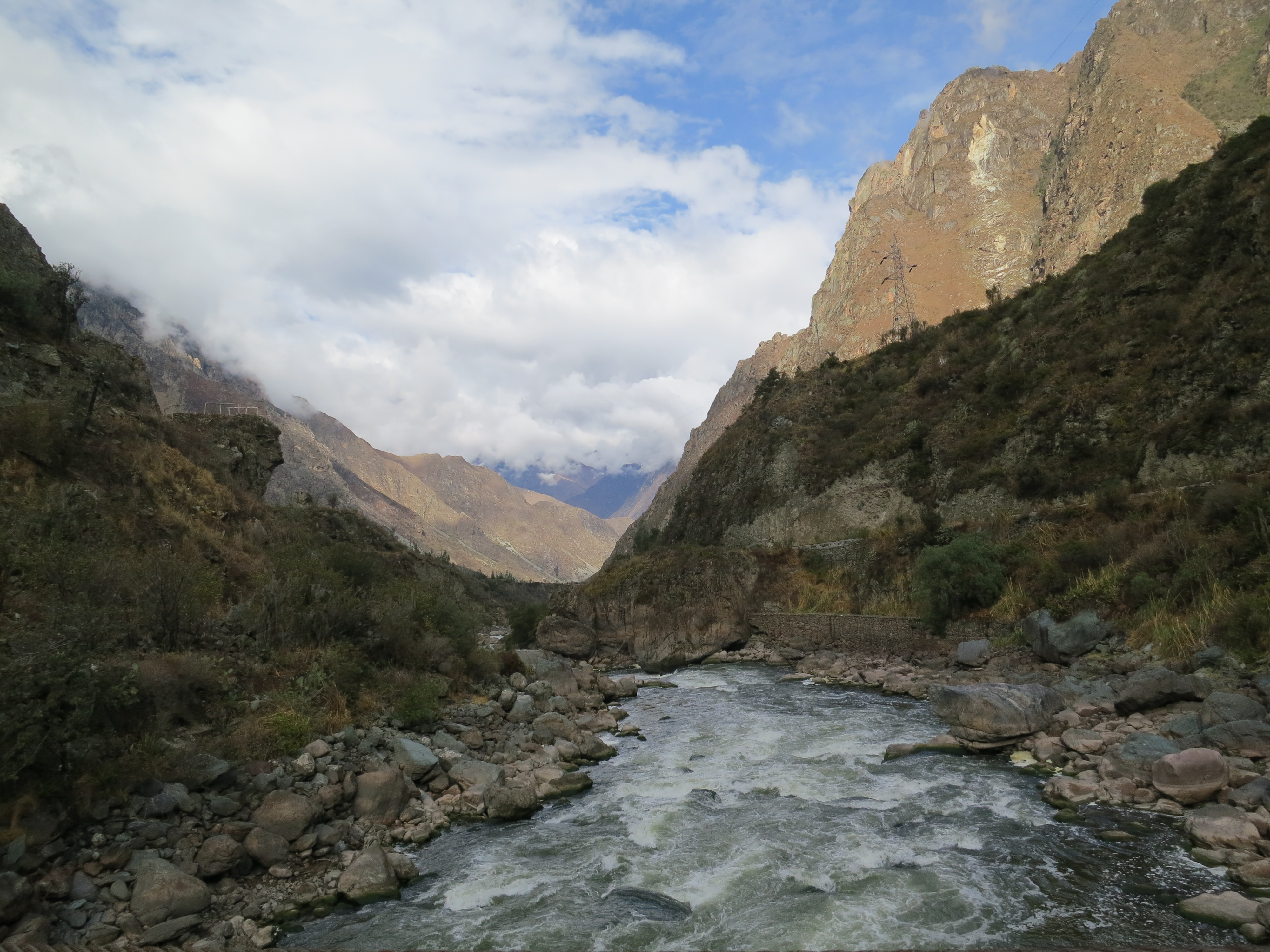
We left Cusco very early in the morning to bus to the trail head by the Urubamba River. We tried to sleep but it was hard due to the bumpy ride. It was dawn as we approached our final stop, Enigma’s basecamp. We groggly ate breakfast and did any last minute preparations. The mist slowly cleared to reveal a mountainous valley along the river. Down the street was the first checkpoint and entry onto the Inca Trail. We went through the checkpoint, crossed the river and were on our way. The beginning portion of the trail winds along the river, past various houses and farms. Each of the houses seemed to have their own restroom available for travelers for the cost of 1 Sol. Not far in, is the elevation map for the trail and the various campsites and mountain passes. Here you can further prepare yourself for what is coming.

img_1965

Our itinerary for the first day was 17km (10.5mi) from the trail head to Llulluchampa which sits at 12,631ft. The first few miles were pretty flat, up until we got to the ruins of Llactapata. A terraced city that sits at a geological fork. To the left of the city is the pilgrimage Inca Trail (which we were on). To the right of the city is the shorter, commercial route to Machu Piccu. From there we started upwards. Always upwards, until we got to Llulluchampa. This is where my shortcomings in writing become more clear. Hiking is such an incredible sensory experience that I find it incredibly difficult to put into words. How do you describe an entirely new environment that you are simultaneously in awe of and laboring through? As we climbed higher, the percentage of stone steps increased. Its pretty impressive how many singular stone steps are actually on this trail. The rocks are not from the mountain itself, they are from elsewhere. I am always thoroughly impressed with what ancient civilizations did. Things that seem God-like even with today’s technologies considering all they had was a mass amount of people’s efforts and maybe a strong grasp of geometry and cause and effect. It makes me feel weak. Especially as I took one step at a time with the entirety of my focus on breathing. Llulluchampa sits partially up the way to Dead Woman’s Pass, the highest point of the trail. The jagged peaks surround the campsite covered in snow with Mt Veronica looming directly in front of the camp. No wonder the Inca revered the glaciers. How could you not?

20160904_145946

Day 2 consisted of 15km (9.3mi) to Phuyupatamarca. The first endever of the day was to get img_1980
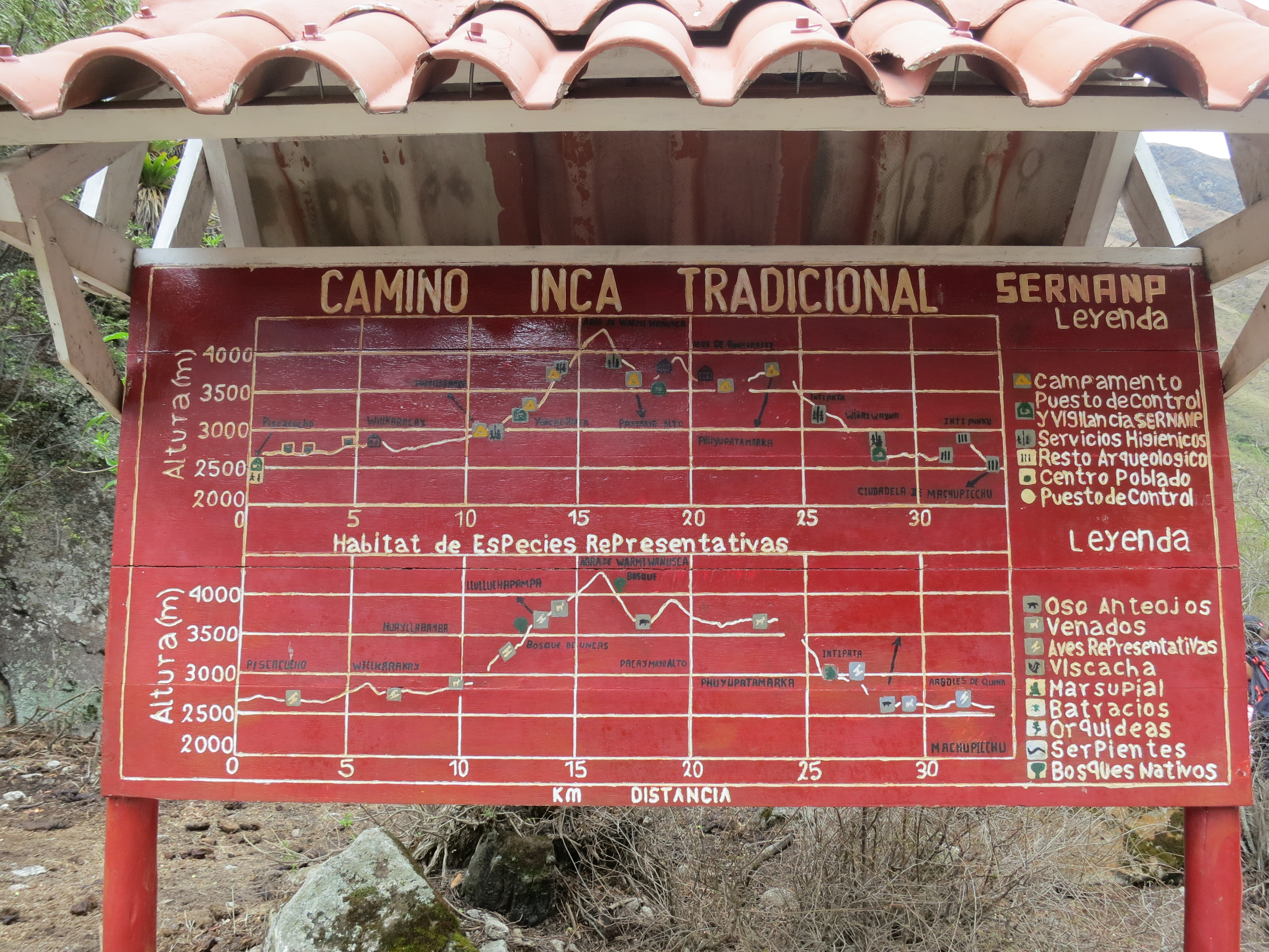
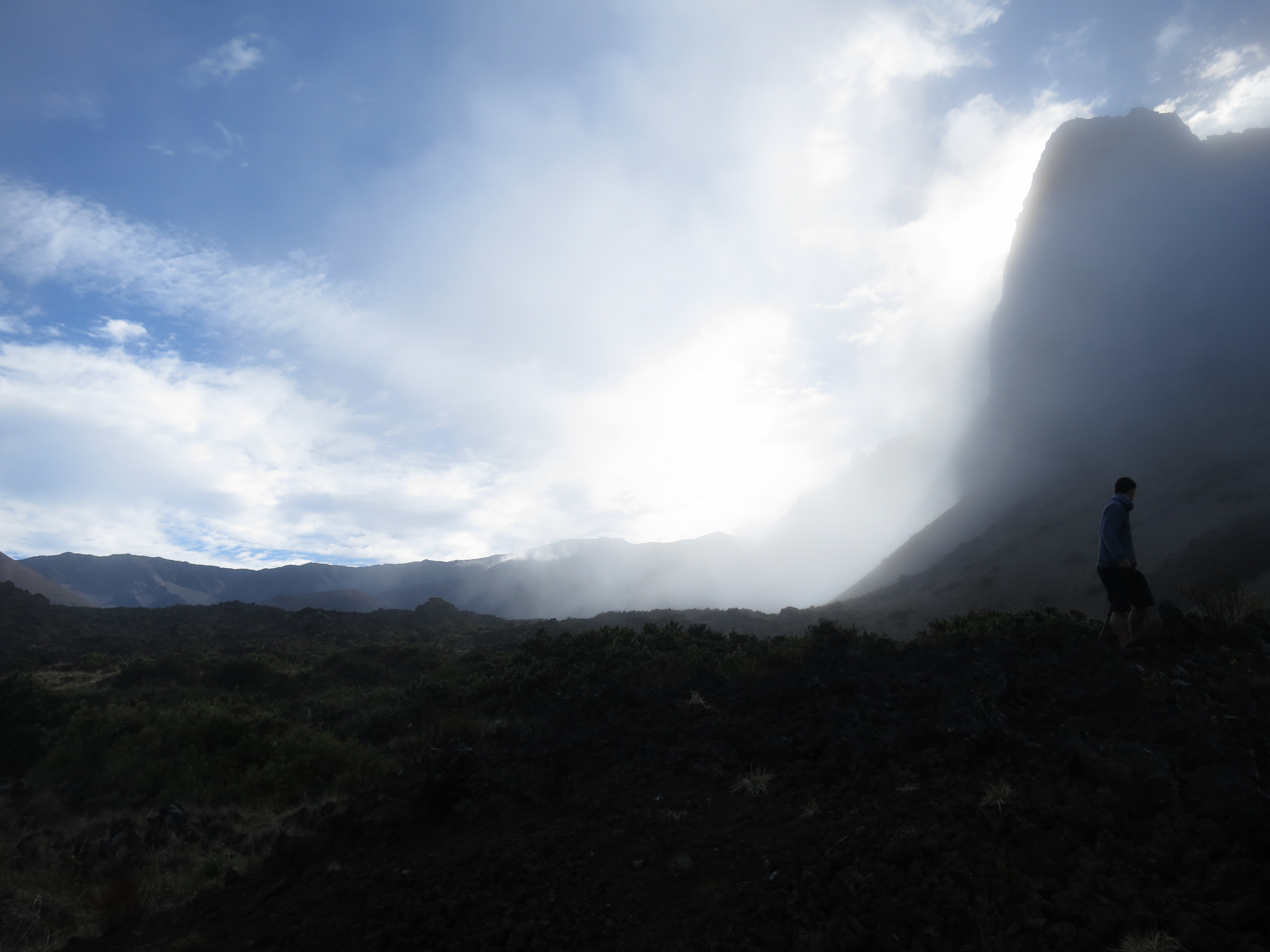
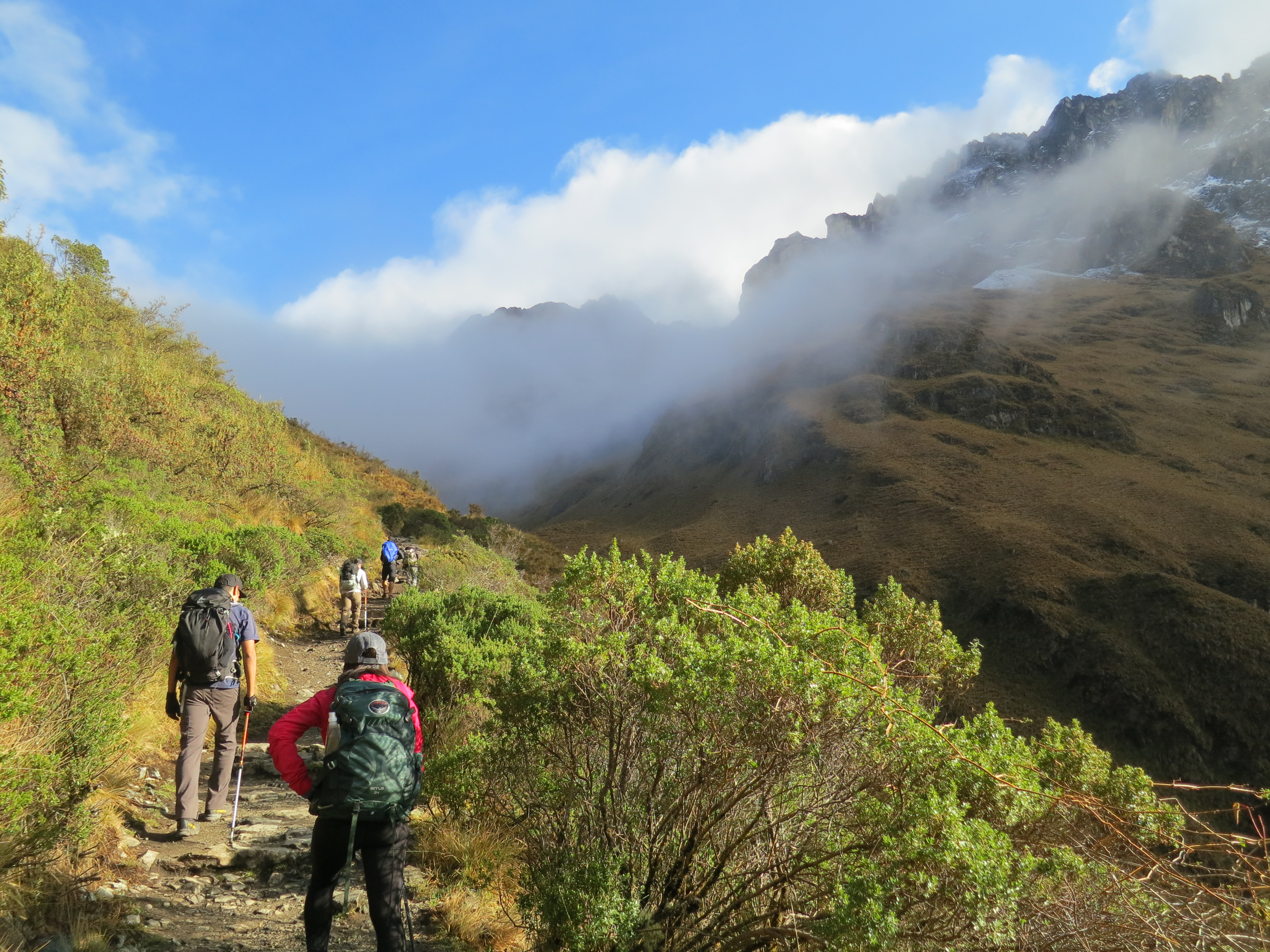
over Dead Woman’s Pass. We were lucky to be treated to blue skies and some low lying clouds. One of my friends did this trail same time of the year and got treated to a freak blizzard. The morning was beautiful and the clouds temporarily cleared as we enjoyed the view from the pass. Felt pretty accomplished to reach the pass which sits at 13,700ft, then felt pretty annoyed having to go down into the img_1984
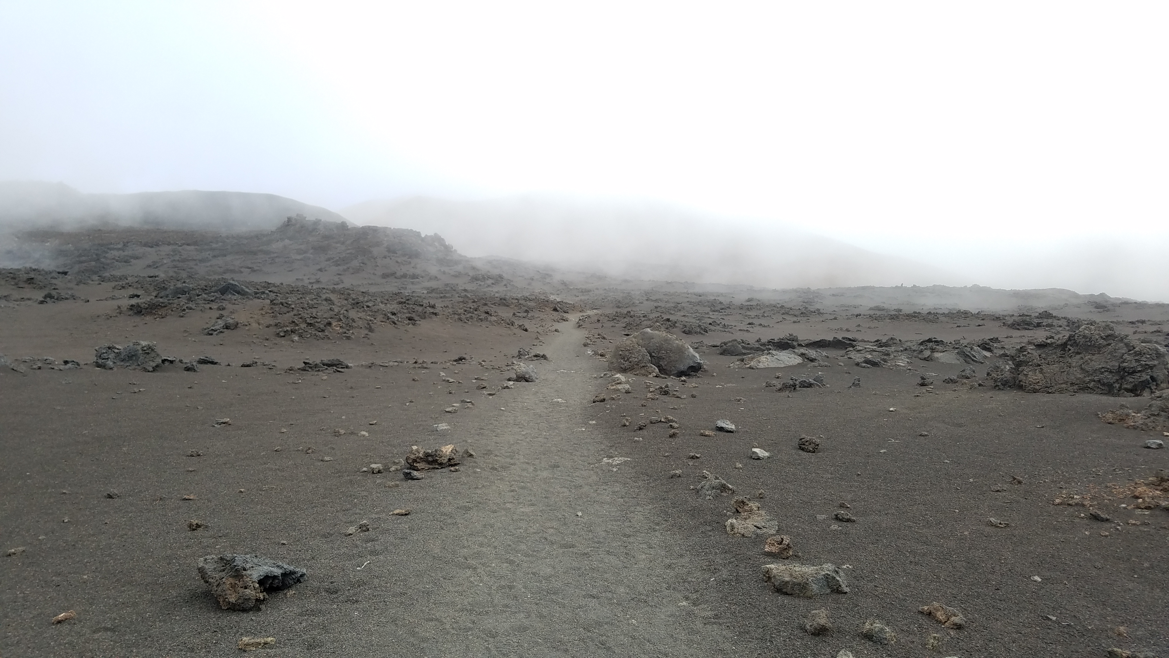
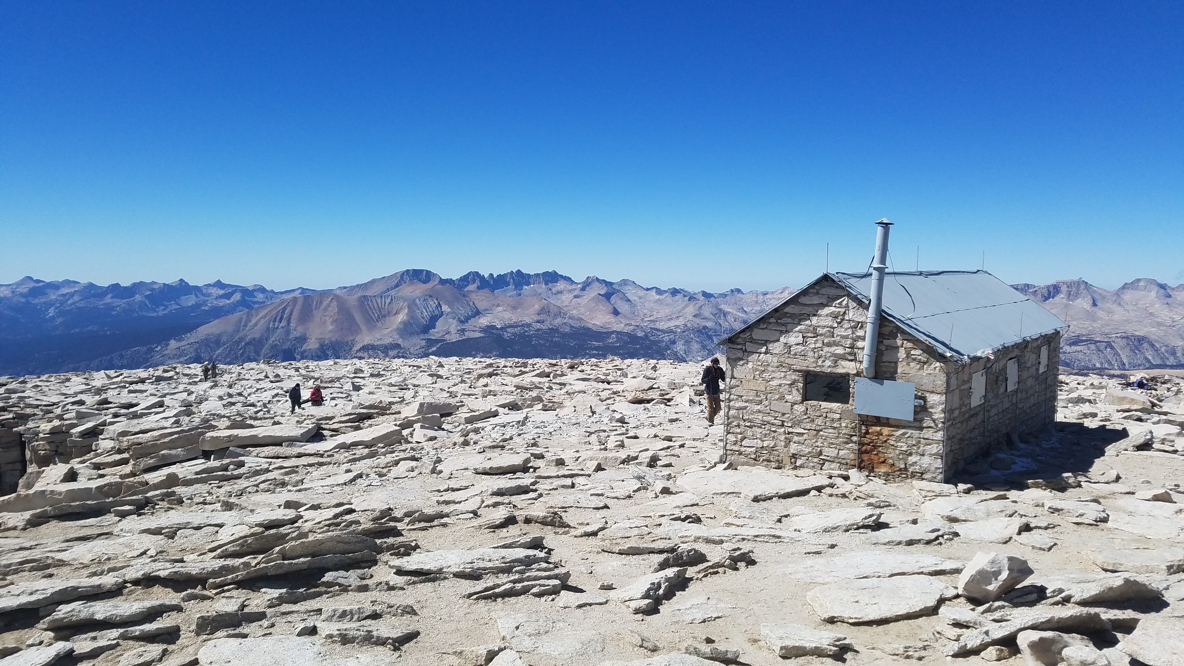
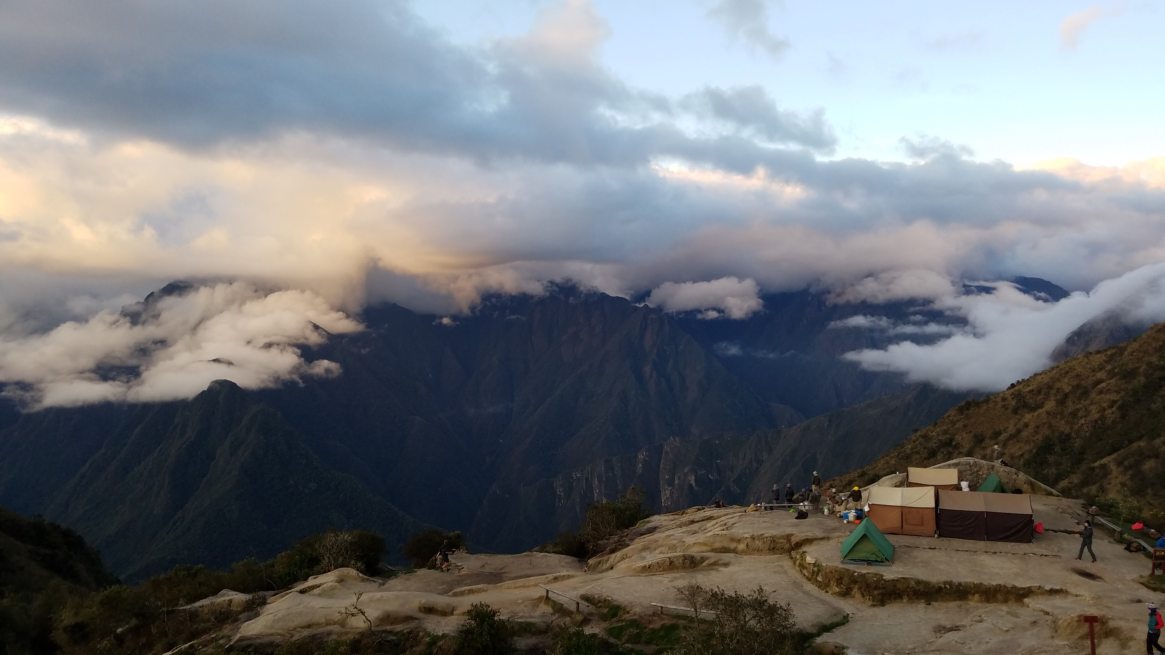
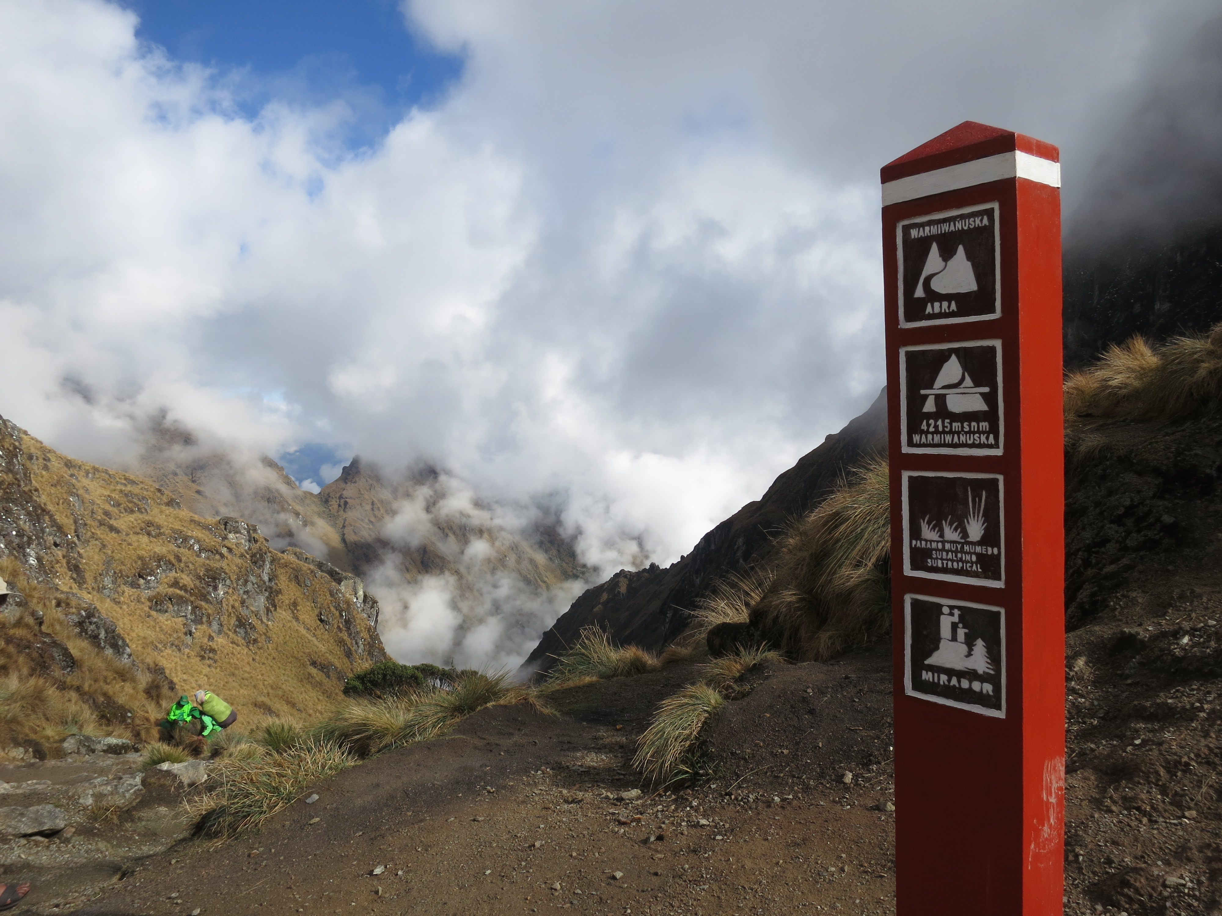
following Pacaymayo valley (11,800ft) only to have to crest the next pass, Abra Runkurakay,  at 13,000ft. But by then, we were getting pretty used to the altitude. It wasn’t quite as difficult to sustain a descent pace. We still had one more valley and one more pass to get to before camp though. Luckily, Abra Phuyupatamarca was relatively easy to go up. You finally break out of the valley and are treated to what I assume are vistas, however all we saw was fog/clouds. This is probably one of the few parts of the trail that actually have shear drops on one side. Nothing we weren’t used to though. We got up to Phuyupatamarca right before sunset. Several other trekking groups were also there so a handful of us perched on the rock above camp wishing for the clouds to part. I was able to snap a few photos before the next wave of clouds rolled in but then resigned myself to the cold and went to the meal tent. 20160905_153219

20160905_153419

Day 3 began around 3:30am. The downside of the 3 day trek is that you do a fair amount of hiking on the last day to get to Machu Picchu. 11km (8.3mi) all downhill. We hiked down 1000s of stone steps in the dark. When the sun finally rose we were in a tropical jungle and then it started to rain. Back at a more reasonable elevation, our spirits were pretty high. We were excited to finally be making it to our destination. 20160906_065954
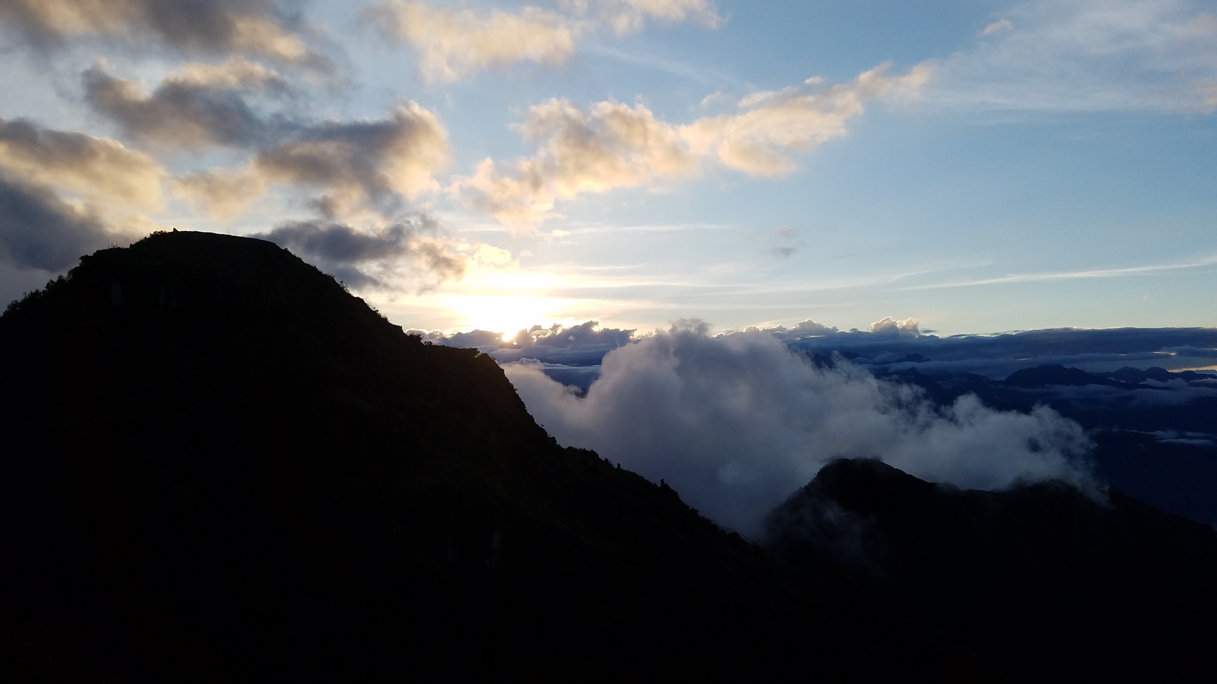
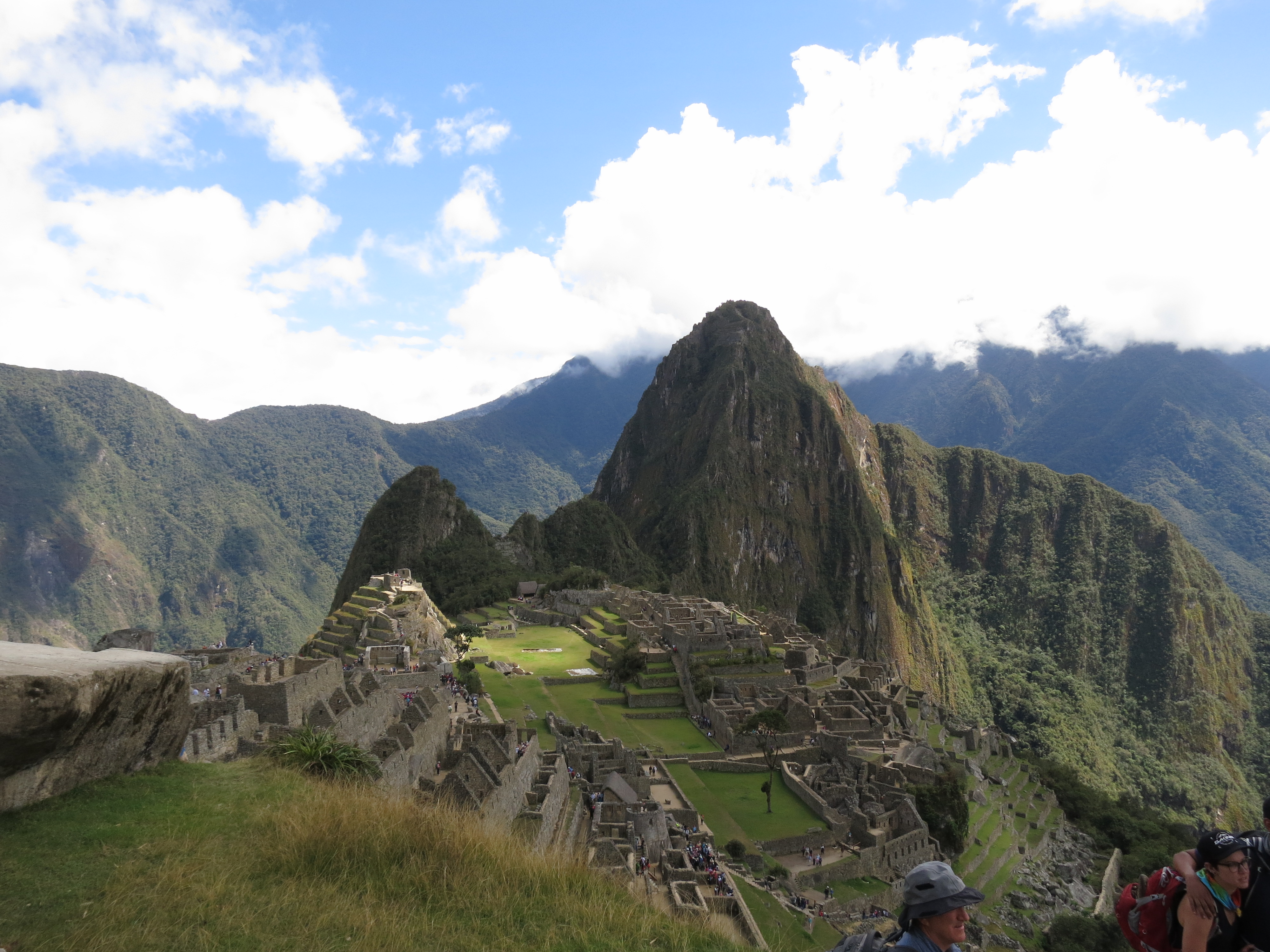
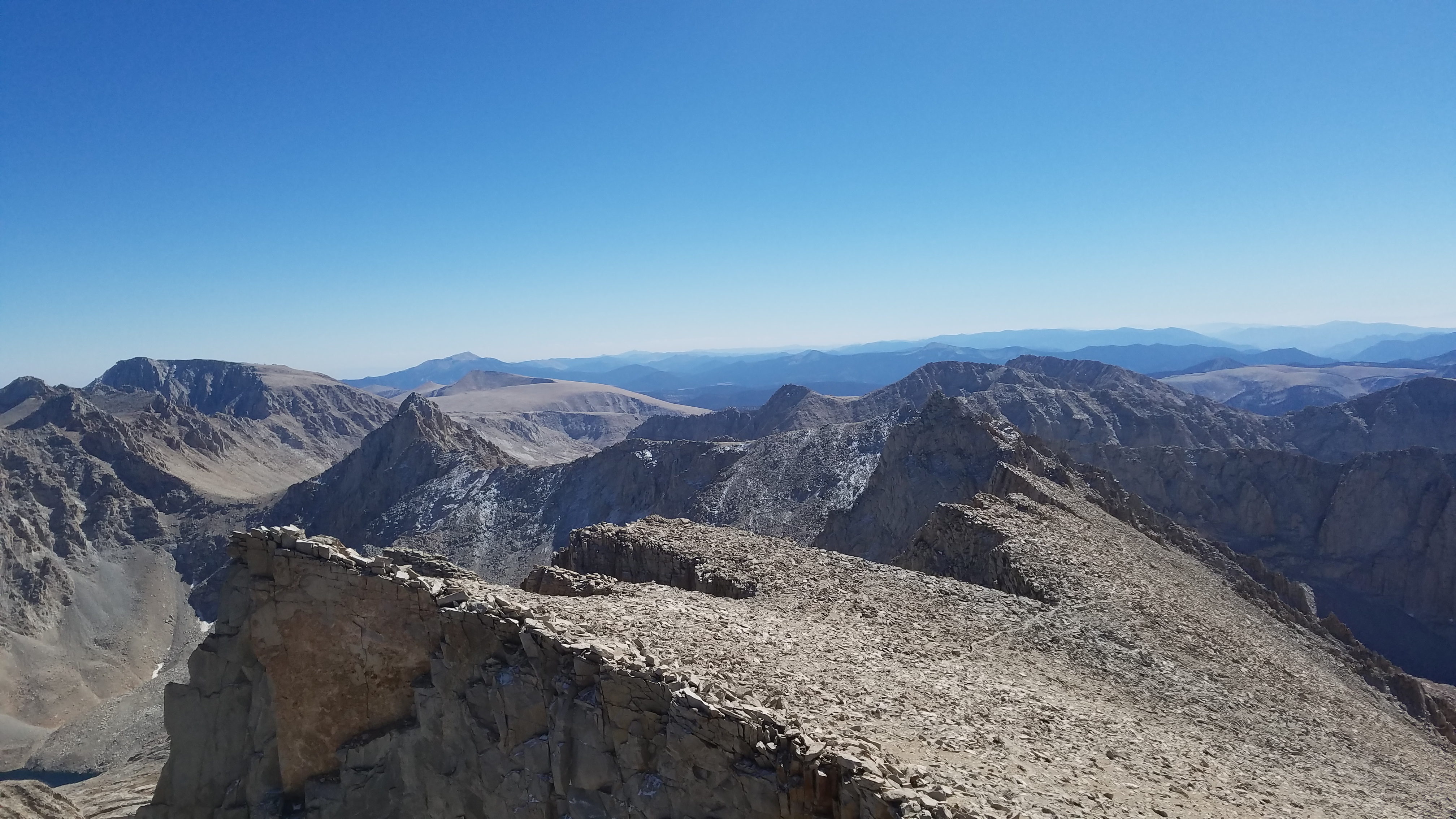
Those last 8 miles seemed to drone on though. The Sungate was our final marker before you drop down into Machu Picchu. It seemed to never come. Somewhere around mile 6 is a very steep stone structure that we thought was the Sungate but to no avail. The steps were probably built on a 45 degree angle. I wasn’t sure whether to climb using my hands or just to walk. We finally reached the real Sungate only to find zero sun and a whole lot of fog. As the whisps flew buy we woulc catch glimpses of the massive valley below, glimpses of a river, of some train tracks, and every now and then Machu Picchu itself. We hung around at the Sungate for a while. It had been a long hike down. My legs felt sort of like jelly. By the time we actually started moving, the low clouds had burned off and the sun was shining bright. We meandered down toward Machu Picchu and were immediately hit by wave after wave of tourists. But weren’t we tourists? Yeah, but we felt like we had done something to earn our way there at least. It was pretty satisfying actually. I feel like if I had just show up on a bus like everyone else it wouldn’t have been as fun. Its like Disney Land on some remote mountain. Lines of people with cameras and all the food is expensive. At least that’s what its sort of turned into. I’m glad some areas are off limits to people. It would be too sad to see something that’s lasted this long turn to ruin because of tourist stampede. Machu Picchu itself is quiet beautiful actually. The whole area is very lush with aqueducts bringing mountain spring water into the city.  The amount of thought that went into choosing this site is astounding. There are terraces for farming. A quarry for building materials. An astronomy tower with windows that line up with the sunrise for winter and summer solstice. I wonder what it was like to live there. I’m so blessed to have had the chance to visit and to hike the Inca Trail. This is why I love travelling.

img_2011


Precipice Lake Backpacking

TL;DR

Explore a bit of the High Sierra trail on the way to one of the most stunning alpine lakes I have ever laid eyes on, Precipice Lake. We did this trip in 4 days, 3 nights. The mileage broke down to 11-9-9-11 roughly. We camped at Bearpaw Meadow the first night and third nights and Precipice Lake the second night. Precipice Lake sits at 10,000ft but the slow ascent of the High Sierra trail made the altitude almost unnoticeable.

slide1

Thoughts

This is one of those girl reads Backpacker Magazine, girl sees a pretty picture, girl plans trip kind of a story.  I’ve wrote about this before, but I’ll say it again, its fascinating to see a plan come to fruition. What started as a simple browsing through a magazine sparked this years 4th of July adventure and our longest backpacking trip to date. The August 2015 issue of Backpacker had a section on their top 26 backcountry lakes. I love alpine lakes. I love the look of the granite, how smooth and bare it is and how suddenly it meets the water. The color of the water is also so pure with its blues and greens. But this lake, Precipice Lake, seemed unreal. It looks like a painting and the artist took liberties to make the sheer wall around it have dark and light stripes that seems completely out of place. The artist then had the audacity to reflect those striations in the lake itself making it look like some deep portal to a parallel world stood at on the other side. I had to go here.

I had never been to Sequoia National Park so I didn’t need much convincing. I looked up the information regarding the permits and the logistics of the hike then waited for the permit release date. Sequoia releases all their permits on the same day, unlike Yosemite who releases them 3 months in advance. Since this hike required something a bit longer than a weekend, we settled on 4th of July and surrounding days. Faxed in our application, got it, then waited for summer. Then the day finally came. We were off on our adventure.

IMG_1914

Ironically, I had obsessed so much about the lake itself that I had neglected to look up much about the trail itself. Precipice Lake sits 20 miles in on the High Sierra trail. I was happily surprised as we started our hike after 1/2 a mile, the trail opens up on a long valley and stays there for the remainder of the hike. I would say 90% of the time you have views of that valley and can see how far you’ve come as well as your ultimate destination. The trail is lined with wildflowers this time of year as well as a myriad of butterflies that danced at your feet. Snowmelt waterfalls grace almost every inlet. This wasn’t some dusty dry boring trail. This was like walking into a Disney movie.

The first leg of our journey took us from Crescent Meadow to Bearpaw Meadow in 11 miles. We saw our first bear! Kind of a big guy tearing into a log about 40 feet upslope of the trail. He didn’t pay us any mind so we didn’t pay him any either and kept going. Bearpaw Meadow has a regular backpackers camp as well as a High Sierra camp for those who want a bit of luxury. We camped at the backpackers camp which isn’t much to be said for. Its down on the slope off the main trail. Not much flat ground. Water is available but not potable. Some of the sites do have an actually bear box which is nice for the overflow of food we brought for the 4 day trip. Campfires are allowed which was a God-send because we were also plagued by mosquitos.

IMG_1921

Day 2 blew us away. From Bearpaw Meadow we made our way up to Hamilton Lakes. The trail is set right on the edge of the mountainside, some portions are even blasted straight through the rock. You cross a waterfall then you’re in Valhalla. Valhalla is an area home to Hamilton Lakes and some striking granite faces. Hamilton Lakes are a stunning place all on their own. If you can manage a 17 mile day, I would highly recommend camping here. The lakes set at the base of a section of 3 miles of switchbacks which means that the mountains jut up right behind them.

IMG_1926

The switchbacks looked like they were going to be the normal grudge but they ended up being not all that bad. Small waterfalls flowed down every few switchbacks allowing us to wet our hats before carrying on. Again, the greenery and the views were just breathtaking as you climb up right along one of the Hamilton Lakes. You top out at another lake that gives you nice overlook of the valley you just hiked up through. But you’re not quite there yet. A few more switchbacks and you come up on Eagle peak which has been in the background of everything throughout the entire hike on the High Sierra trail. At the base of Eagle Peak is Precipice Lake.

I couldn’t believe I was actually there. It was pretty surreal to be there in person.

IMG_1929

We got there with enough time to relax, lay around, take pictures, set up camp, make dinner, and eat all before sunset. We watched the ice float around the lake and played around on the boulder field. There weren’t many campsites there, especially with all the snow coverage. But we got one that was up off the to the right of the trail to Kaweah Gap so we had views of both Valhalla and Precipice. An early sunset in the mountains sans clouds turned into the perfect star viewing night. One by one they came out until the whole of the Milky Way banded across the sky. D took some pretty amazing shots with his Sony Alpha. Unfortunately, my cameras aren’t up to caliber for night shots. We drifted off to sleep under the stars, snug in our bivies. What an amazing place to be. I still can’t believe it. It could’ve all been a dream.

The next morning we got up early to catch the sunrise and enjoy the lake a bit more before heading out. We would get to enjoy the cool morning air as we did the switchbacks down to Hamilton and then decided to lounge at the middle lake for an early lunch enjoying everything all over again. We camped at BearPaw again and then it was time to go home.

IMG_1924
Valhalla – Angel Wings in the background

References

The original Backpacker Magazine article that inspired this trip can be found here.

10 Lakes Backpacking

TL;DR

Awsome area of Yosemite that’s only 6.4mi from Tioga Road? That would be 10 Lakes Basin. Its approachable from either the 10 lakes trail head off 120 or the longer way from Tuolumne Meadows. We did this hike in June and there was still up to 10 feet of snow in some parts of the pass (9600ft elevation). Enough snow to lose the trail for a mile. 6.4 miles is just to the basin itself. From there you have 2 lakes in the near vicinity. The other lakes require further hiking.

You can apply for permits up to 24 weeks in advance.

10Lakes

Thoughts

Every year we try and go to Yosemite at least a few times. The wilderness is so vast that, every time we go. we can see something new. A coworker recommended this hike to D so I snagged permits the day they were made available (getting backpacking permits for summer in Yosemite is furious business). This isn’t the most strenuous of trails nor the most scenic until you get to your destination. However, perhaps it was the seasonal timing, but parts of it were quite magical looking. The trail starts off with the standard Yosemite terrain: granite and forest. A few miles, in more and more snow patches started to appear. 5 miles in you hit the switch backs. I imagine during the late summer the switchbacks are dusty stone steps. For us, they were all streams of snow melt. All streams. Streams everywhere. Which made brought to mind the name Riverlands from Game of Thrones. The sounds and sight of it all was unlike anything I could imagine although theoretically, I guess that’s exactly what would happen. The trail provides the path of least resistance.

IMG_1882

Once we topped out on the pass we were met with quite a conundrum. We didn’t know where the trail was. Everything was covered in snow. I had my map and a compass and luckily the features of the pass are pretty easy to follow. The questionable part was when to crest the ridge. We followed the ridge as far as we could go without dropping down into the Grand Canyon of the Tuolumne. It was pretty slow work. We weren’t post-holing but the snow had been hardened into mini mogels  so it became quite
the leg workout. I don’t know what I would’ve done without my hiking poles. Sunset was approaching and we still weren’t positive where to go. Altitude affects were kicking in and we just wanted to eat and go to sleep. Before the drop down into the canyon, we found a rocky area on its own small ridge where we could set up the tent and figure out things in the morning. Being lost wasn’t all terrible though. We were able to see a wonderful Yosemite sunset.

IMG_1888

The next day we decided we’d hike up the ridge to the east. If we couldn’t find the trail from there we would call it quits. A short warm up hike and we made it to the top. With relief we gazed upon the 10 lakes basin. 2 of the lakes in easy view. Plus the snow was gone on this side of the ridge and we quickly picked up the trail again. Once in the basin we wondered around a bit (lost the trail in the snow again) and made our way over to the main lake. We were told by the ranger giving out permits that there were established fire rings scattered around the area. We weaved around the granite boulders for a bit looking for a campsite with a fire ring. A few yards from what is probably the largest boulder in the area, we found a wonderful campsite complete with flat ground, fire pit, and a view of the main lake. We spent the rest of the day exploring around the lake, climbing logs, scrambling, crossing streams and picking out good spots for sunset photographs.

IMG_1892

This was the first time I’ve been hiking in that middle ground between snow covered and dry. The snow very much covered the majority of the land but it was in a state of distress. It had been melting for a while and will continue melting all summer. But because this area sees little traffic in the early season, everything was untouched. Fragile ice bridges formed across the streams creating small tunnels that streams wove in and out of. The snow melt caused the streams to surge over their banks combing the long grass toward the lake. The scenery brought to mind the aesthetic that Japanese gardens seek to portray. But this was the real thing. This was tranquility. This was zen. This was that inner calm, God within us, that buffers us from the outside world. And all I could do was breathe and listen to the rushing waters. Breathe and be thankful that this place exists in such a modern world and that I am able to seek it out.

Exploring Lassen Volcanic

TL;DR

All the beauty of the mountains in addition to some incredible geological features. You won’t be able to see anything like this anywhere else in California. There’s wide variety of trails to choose from and create your own trip. Plus, no entering lotteries for permits!

Backpacking Permit Information

 Thoughts

Last September, some friends and I spent an extended weekend up in Lassen Volcanic National Park. One of the less frequented parks of the NPS for reasons I (now) don’t understand. Apparently its one of California’s best kept secrets. Truthfully, I didn’t actually know about this park until I decided to pursue my Journey to 59, and I’m a California native. Its located in the north eastern part of the state a few hours south of the Oregon border. The drive there was as simple as it gets. North on I5 and cut east at Red Bluff (We did a small detour through Chico to get In N Out….don’t judge us).

I had started planning this trip earlier this year. I guess having to always jump on backcountry permits at Yosemite got me nervous. It turned out I didn’t need to worry. Late September is officially the off-season at Lassen. While you can apply for permits through fax, you can just as easily pick one up from the Visitor Center. I planned for September to avoid any summer heat and crowds. We lucked out with the weather, just missing an early snow by a few days. Nights were chilly in the mid 30’s and days were warm in the mid 70’s-80’s. We got to see Mt Lassen with a beautiful fresh coat of snow as opposed to it looking like a dirt hill. Also, there were no crowds, let alone people. I think the total people we saw within 4 days was less than 25.

As the name suggests, Lassen Volcanic NP (LAVO) is home to volcanic activity. Its the second most active geothermal area in the continental US behind Yellowstone. Last year they are celebrating 100 years since Mt Lassen last erupted.

I planned out a backpacking loop that would cross some of the distinguished features of the park: Cinder Cone, Painted Dunes, Rainbow Lake, Snag Lake, the PCT, Warner Valley and Devil’s Kitchen. A rough map of the loop we did can be found here. Lassen does have bears, although according to the ranger at the visitor center, ” They’re not like those Yosemite bears”. Bears cans are fine, but you can also just hang your food.

We rolled into Lassen with a few hours of daylight so we took a short hike (~3 miles RT) to Bumpass Hell. Bumpass hell is one of the more accessible geothermal areas and has a bunch of decks set up to help visitors see the mud pots and thermal vents.  Steam constantly rises and the smell of sulfur is close to nauseating. Got back to the car as the sun set and headed over to the campsite. Temperatures plunged once the sun went down to a chilly mid 30’s.

The next day we got up not as early as planned but on our way none the less. Moved our cars to the trail head at Summit Lake. The beginning of the trail takes you through some high sierra forests filled with pines and manzanita. The sky was a crisp blue with not a cloud to be seen (actually we only saw one cloud on this entire trip). We passed several lakes on the way to Rainbow Lake, stopping to eat lunch and take in the scenery. Once at Rainbow Lake we snagged a spot in the wooded area to the south. The effects of the drought clearly seen in the receded lake shore that opened up a wide expanse of beachy sand. No time to rest, as we set off to do a day hike to the Cinder Cone and Snag Lake.

This day hike might have been a bit hopeful on my part. The quarter mile surrounding the Cinder Cone in addition to the Cinder Cone itself is sand. You’re hiking in sand. And if you’ve ever hiked or walked in sand you’ll notice how much more tired that makes you. But at the time you don’t notice it, the volcanic sand is dark with striations of red which gives it an almost painted feel (hence Painted Dunes). Its quite unworldly looking which is why I say its unlike anything else in California. The path to the summit of the Cinder Cone is steep and made of sand and loose rock. Imagine slipping back a foot for every step you take. Once you’re on top you have the option of hiking down into the crater which we opted not to. You have a fantastic view of the surrounding area as well as Mt Lassen.

After our exhausting journey around the Cinder Cone we continued on to Snag Lake. Its a beautiful area and saw a bunch of people camped out in the surrounding woods. Looks like they were fishing. Sun began to set and we were rewarded with a nice alpenglow on the surrounding hills. The last mile and a half we were all in a bit of a daze. The sun had set and we pretty much just wanted dinner.

The next day we parted ways and D and I continued down the PCT to Corral Meadow. I wanted to see the Devil’s Kitchen, another major geothermal area that isn’t as accessible as Bumpass. You can drive to Warner Valley but its a bit out of the way. We set up camp at Corral Meadow, a nice little area close to the stream. We day hiked the next day down to Warner Valley and Devil’s Kitchen. It was worth it, Devil’s Kitchen was much larger than Bumpass Hell and also had a great deal for foliage making it seem primordial almost. Large ferns grew next to steaming streams and vents. We had a bit more energy than expected so we decided to break camp and hike back to the car after. We were ready for a shower.

Ohlone

Ohlone Wilderness Trail

TL;DR

Its pretty incredible that you can hike for 28 miles through the Bay Area while still being in a pretty remote area. Very glad we did it during the spring. Got to enjoy the wildflowers and the moderate weather. If you don’t have time for the whole thing, check out Sunol or Del Valle regional parks. They were my favorite parts.

Where we camped: Sky Camp (Sunol Backpackers Camp)
When we went: April 1, 2016ohloneinfo
Day 1: 16mi
Day 2: 12mi
Permit Info: Ohlone Wilderness

Thoughts

Where to begin. So the Ohlone wilderness trail has been on our list of things to do for a while. Its local to the Bay Area and has moderate weather in the spring and fall. It goes through Sunol, which is one of our favorite areas to go hiking. In preparation for Peru (and now Whitney), I wanted to do a variety of hikes that stretch our daily mileage and/or deal with elevation change and altitude. The Ohlone trail can be drawn out as long as you want but a lot of hiking overviews I’ve seen do it in two or three days. Depending on where you camp, your daily mileage ends up being anywhere from 3 miles to 25 miles. But I wanted to challenge myself. I had never done this long of a backpacking trip and I had never backpacked 16 miles in a day. So that’s what we did.

The Ohlone Wilderness trail runs from Del Valle Regional Park in Livermore to the Stanford Ave Staging Area at Mission Peak in Fremont. The trail can be done either east to west, or west to east. While the elevation profile is a bit more daunting going east to west, there are a few perks to make up for it. The approximate halfway point lands you in Sunol, one of my favorite places in the bay area. The Ohlone trail is slightly restrictive in where you can camp. There’s a handful of campgrounds you can choose from spread out around the trail. One of these is the Sunol Backpacker’s camp, nestled just inside the boundary of Sunol Regional Wilderness. The other slight benefit to starting in Del Valle is that if you leave a car there, its a bit more safe. A common complaint for cars parked in Fremont is that they could get broken into.

Without really knowing anything about the backpacker camps, I chose Sky Camp thinking that maybe it had a nice view of Little Yosemite in Sunol. Then on April 1, we drove out to Del Valle and started walking. The first 7 miles are pretty much an uphill climb toward Rose Peak. Never. Ending. Uphill.But once you reach Rose Peak, you’re on a gradual decent through an array of Lupine, Poppies, and Sticky Monkey Flower. Sky Camp sits on a hillock all by its lonesome. The next morning the fog had rolled in thick into Sunol Valley. We watched it ebb and flow as the sun came up.

IMG_1876

Day 2 simply proved that day 1 had the best scenery. Day 2 was more of an uphill grind as you climb back up what you had lost the previous day. You get some views of the Livermore/Pleasanton area but its a bit lackluster compared to Sunol. Not really many wildflowers. Much more poison oak. Call me a snobby hiker. Hiking on fire roads just isn’t my thing. Mission Peak was in the middle of its weekend onslaught of hikers and runners when we got there. My feet were slowly in the process of dying (and I have since bought new hiking boots). Crossing the gate into the Stanford Staging area never felt more rewarding though. I feel like I can take on the world now….or at least our next epic backpacking trip.