
TL;DR
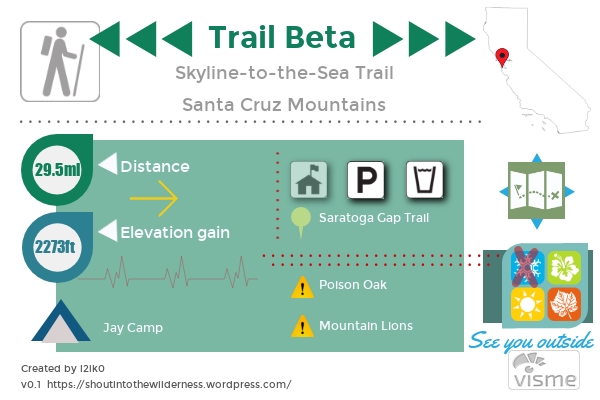
Enjoy all the Santa Cruz mountains have to offer in this ~30 mile thru-hike from Skyline Ridge to the Waddle Beach. Official trail starts at Saratoga Gap, however, overnight parking isn’t allowed there. If you aren’t lucky enough to have a drop-off, you can park at Castle Rock State Park and add on 3.5mi. Traditionally done in 3 days, we did it in 2 with a big 18.5mi first day from Castle Rock SP to Big Basin SP. A car shuttle of some sort is necessary for this hike. You are required to camp in designated campgrounds along the trail. Most campgrounds are closed during the winter and the agency will not issue permits until they open. The majority of the trail is shaded although temperatures can get warm during the summer months.
Permits
A big beef I have with the backpacking around the Bay Area is how convoluted the permitting process is. Top hits when googling “Skyline to sea” don’t actually send you to any agency where you can get permits. Navigating Redwood Hikes sends you to a backcountry trail camps site where you can actually start the process. Here is a summary step-by-step of how we got our permits for S2S (as of June 2018).
- Plan out how many miles you want to do a day and what campsites that puts you near. Redwood Hikes does give a great overview of the trail, the different parks you hike through, and where the campgrounds are.
- Check campsite availability to see if the dates you want are available. A “(0)” next to the campground means there are no sites available there. Limit is 6 people per site.
- Up to 60 days before your planned dates, submit a Backcountry Trailcamp Request
- Wait until they email you back saying that you have been “approved”
- If you have been approved, you now have until 5PM the next business day to call (831)338-8861 (during business hours) and submit payment. If you don’t do this in time, your request is cancelled, and you must start all over again.
- After paying over the phone, they will email you your backpacking permit as well as 1 parking permit. If you are planning on parking a car at either end, you will need to pay for the second car upon arrival.
Thoughts
I have some pretty mixed feelings about this trail. Some parts were just a grind and a bore to get through while other parts were absolutely gorgeous and wonderful to be in. First and foremost, we mostly used this as a gear test/training hike for the JMT. We had a group of 4 and 2 cars, one for either end. The morning of we drove out to Waddell, dropped off one car and then continued on to Castle Rock. This whole process took 2 hours starting from Oakland. The Castle Rock parking lot is pretty heinous. It fills up ridiculously early due to the popular rock climbing there and they don’t reserve spots for overnight backpackers. We arrived at the lot around 9:30am and it was completely full so we had to wait and pray that someone who did an early hike would leave. God must have been looking in our direction because we only had to wait about 15 minutes. 10am isn’t that great a start when you have 18.5 miles to do.
I would say our day 1 was pretty bland. If you start from Castle Rock, you will meander along the Saratoga Gap trail until it meets up with the official Skyline-to-the-Sea trail. Castle Rock is unfortunately within very close proximity to an outdoor gun range. For the first 3-4 miles the ambiance consists of periodic gun fire. Once you have traveled out of hearing range of the gunfire, you get to travel directly next to highway 9 where you can enjoy the sounds of passing traffic. There were also a couple abandoned cars that looked like they careened off the highway. The dense foliage made them unsalvageable.
We stopped at the Waterman Gap Trail Camp for lunch and to refill our water. Its a bit depressing to stop for lunch at 9 miles and realize you’re only halfway done. The camp was very nice. We sat around an unoccupied campsite to eat. Soon after we were on our way again. The rest of the day passed by in a mosquito filled haze and we rolled into Big Basin well after dark and then finally to Jay Camp around 10PM. Jay Camp is a bit off the trail and involved wondering through the Big Basin parking lots for roughly a mile before finding the camp.

Jay Camp itself was also very nice. You aren’t assigned a site prior to getting there, you just find one that unoccupied. We managed to grab Site 1 which had two good spots for 2 person tents as well as a highly needed picnic table to sit around. Flush toilets, sinks, as well as showers area available next to the campground.
Day 2 arrived and we didn’t pack up as early as I had wanted to. The pros and cons of hiking in a group. This is the same group that we’ll be hiking the JMT with. Here’s hoping that we start earlier than 10 during that trip.
Hiking through Big Basin was significantly better than Castle Rock. The foliage is more forest than brush and its hard to beat hiking through redwoods. We had to take some detours due to trail closures which added on an extra mile. The trail follows a creek system all the way to the beach. Coincidentally, we once again ended up hiking the same day as an Ultramarathon. A couple miles in the runners caught up to where we were and we had to start paying attention and letting them pass.
All in all, it was an alright trip and I’m glad we did it. We had ulterior motives and were going for high distance days so it was hard to really enjoy (hence my lack of photos). Plus I’m still getting used to this camera ><

